Parnera geodata
Parnera (Gujarat) is a populated place; located in India in Asia/Kolkata (GMT+5.5) time zone. With population of 11,434 people, there are 2783 cities with bigger population in this country. Compared to other cities in India, 63.4% of cities are located further ↑North; 95% of cities are located further →East and 85.5% of cities have higher elevation than Parnera. Note1


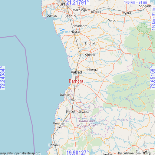
Parnera GPS coordinates[2]
20° 33' 39.636" North, 72° 56' 54.456" East
| Map corner | latitude | longitude |
|---|---|---|
| Upper-left | 21.21791°, | 72.24534° |
| Center: | 20.56101°, | 72.94846° |
| Lower-right: | 19.90127°, | 73.65159° |
| Map W x H: | 146.4×146.4 km | = 91×91mi |
| max Lat: | 34.9274° ⇑63.4% North |
| Parnera: | 20.56101° |
| min Lat: | ⇓36.6% South 8.09008° |
| min Long | Parnera | max Long |
| 68.82655° | 72.94846° | 96.81° |
| W 5%⇐ | ⇒95% E |
Elevation
Elevation of Parnera is 29 m = 95 ft, and this is 266.6 m = 875 ft below average elevation for this country.
| Max E: |
3681 m = 12077 ft | 85.5% |
| Avg. | 295.6 m = 970 ft | |
| Parnera | 29 m = 95 ft | |
Min E: |
1 m = 3 ft | 14.5% |
See also: India elevation on elevation.city.
Geographical zone
Parnera is located in North Torrid zone (between Equator and Tropic of Cancer). Distance of this Northern Tropic circle is 319.7 km =198.7 mi to North.| Distance of | km | miles | from Parnera |
|---|---|---|---|
| North Pole | 7720.9 | 4797.5 | to North |
| Arctic Circle | 5115 | 3178.3 | to North |
| Tropic Cancer | 319.7 | 198.7 | to North |
| Equator | 2286.2 | 1420.6 | to South |


Nearby cities:
15 places around Parnera: (largest is in red/bold)
• Abrama
33.4 km =20.8 mi,  352°
352°
• Bilimora
23.2 km =14.4 mi,  3°
3°
• Chikhli
24.9 km =15.5 mi,  28°
28°
• Dadra
26.3 km =16.3 mi,  175°
175°
• Daman
20.3 km =12.6 mi,  216°
216°
• Dharampur
23.6 km =14.7 mi,  96°
96°
• Gandevi
28.4 km =17.6 mi,  10°
10°
• Jalālpur
43.5 km =27 mi, 353°
• Navsāri
42.5 km =26.4 mi,  356°
356°
• Pārdi
5.8 km =3.6 mi, 182°
• Silvassa
32.3 km =20.1 mi,  171°
171°
• Valsād
5.7 km =3.5 mi,  344°
344°
• Vapi
21.5 km =13.4 mi,  192°
192°
• Vānsada
48.5 km =30.1 mi,  63°
63°
• Āmli
31.7 km =19.7 mi, 167°
Sources, notices
• [Note1] Compared only with cities in India existing in our database
• [Src1] Map data: © OpenStreetMap contributors (CC-BY-SA)
• [Src2] Other city data from geonames.org with taken over terms of usage.
• [Src3] Geographical zone / Annual Mean Temperature by Robert A. Rohde @ Wikipedia
