Valsād geodata
Valsād (Gujarat) is a seat of a second-order administrative division; located in India in Asia/Kolkata (GMT+5.5) time zone. With population of 72,929 people, there are 603 cities with bigger population in this country. Compared to other cities in India, 63.3% of cities are located further ↑North; 95.2% of cities are located further →East and 94.3% of cities have higher elevation than Valsād. Note1


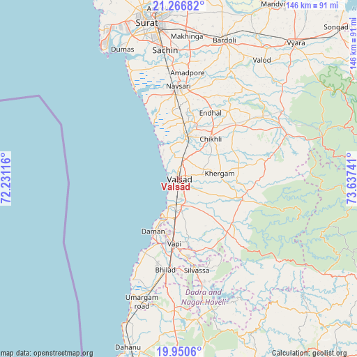
Valsād GPS coordinates[2]
20° 36' 36.468" North, 72° 56' 3.408" East
| Map corner | latitude | longitude |
|---|---|---|
| Upper-left | 21.26682°, | 72.23116° |
| Center: | 20.61013°, | 72.93428° |
| Lower-right: | 19.9506°, | 73.63741° |
| Map W x H: | 146.3×146.4 km | = 90.9×91mi |
| max Lat: | 34.9274° ⇑63.3% North |
| Valsād: | 20.61013° |
| min Lat: | ⇓36.7% South 8.09008° |
| min Long | Valsād | max Long |
| 68.82655° | 72.93428° | 96.81° |
| W 4.8%⇐ | ⇒95.2% E |
Elevation
Elevation of Valsād is 12 m = 39 ft, and this is 283.6 m = 930 ft below average elevation for this country.
| Max E: |
3681 m = 12077 ft | 94.3% |
| Avg. | 295.6 m = 970 ft | |
| Valsād | 12 m = 39 ft | |
Min E: |
1 m = 3 ft | 5.7% |
See also: Valsād elevation on elevation.city.
Geographical zone
Valsād is located in North Torrid zone (between Equator and Tropic of Cancer). Distance of this Northern Tropic circle is 314.3 km =195.3 mi to North.| Distance of | km | miles | from Valsād |
|---|---|---|---|
| North Pole | 7715.4 | 4794.1 | to North |
| Arctic Circle | 5109.5 | 3174.9 | to North |
| Tropic Cancer | 314.3 | 195.3 | to North |
| Equator | 2291.6 | 1423.9 | to South |


Nearby cities:
15 places around Valsād: (largest is in red/bold)
• Abrama
27.8 km =17.3 mi,  354°
354°
• Bilimora
18 km =11.2 mi,  9°
9°
• Chikhli
21.1 km =13.1 mi,  39°
39°
• Dadra
31.9 km =19.8 mi,  174°
174°
• Daman
24.2 km =15 mi,  205°
205°
• Dharampur
26.2 km =16.3 mi,  108°
108°
• Gandevi
23.4 km =14.5 mi,  16°
16°
• Jalālpur
37.9 km =23.5 mi, 354°
• Navsāri
37 km =23 mi,  358°
358°
• Parnera
5.7 km =3.5 mi,  164°
164°
• Pārdi
11.3 km =7 mi, 173°
• Silvassa
38 km =23.6 mi, 170°
• Vapi
26.7 km =16.6 mi,  186°
186°
• Vānsada
47.6 km =29.6 mi,  69°
69°
• Āmli
37.3 km =23.2 mi, 166°
Sources, notices
• [Note1] Compared only with cities in India existing in our database
• [Src1] Map data: © OpenStreetMap contributors (CC-BY-SA)
• [Src2] Other city data from geonames.org with taken over terms of usage.
• [Src3] Geographical zone / Annual Mean Temperature by Robert A. Rohde @ Wikipedia
