Gudāri geodata
Gudāri (Odisha) is a populated place; located in India in Asia/Kolkata (GMT+5.5) time zone. With population of 6,895 people, there are 3222 cities with bigger population in this country. Compared to other cities in India, 67.4% of cities are located further ↑North; 81.4% of cities are located further ←West and 64% of cities have higher elevation than Gudāri. Note1


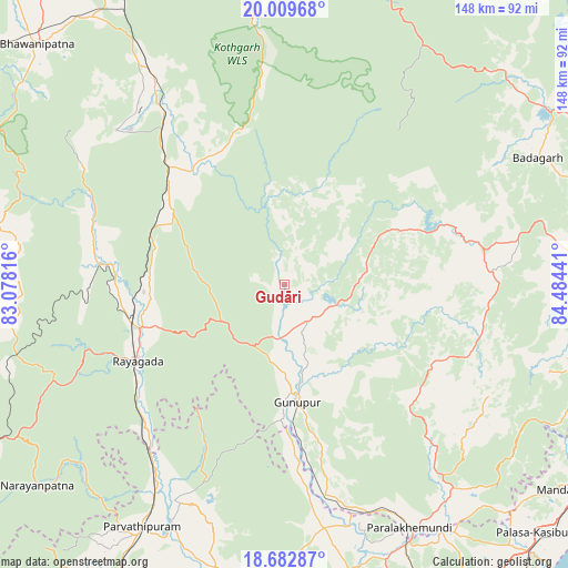
Gudāri GPS coordinates[2]
19° 20' 51.432" North, 83° 46' 52.608" East
| Map corner | latitude | longitude |
|---|---|---|
| Upper-left | 20.00968°, | 83.07816° |
| Center: | 19.34762°, | 83.78128° |
| Lower-right: | 18.68287°, | 84.48441° |
| Map W x H: | 147.5×147.5 km | = 91.7×91.7mi |
| max Lat: | 34.9274° ⇑67.4% North |
| Gudāri: | 19.34762° |
| min Lat: | ⇓32.6% South 8.09008° |
| min Long | Gudāri | max Long |
| 68.82655° | 83.78128° | 96.81° |
| W 81.4%⇐ | ⇒18.6% E |
Elevation
Elevation of Gudāri is 127 m = 417 ft, and this is 168.6 m = 553 ft below average elevation for this country.
| Max E: |
3681 m = 12077 ft | 64% |
| Avg. | 295.6 m = 970 ft | |
| Gudāri | 127 m = 417 ft | |
Min E: |
1 m = 3 ft | 36% |
See also: India elevation on elevation.city.
Geographical zone
Gudāri is located in North Torrid zone (between Equator and Tropic of Cancer). Distance of this Northern Tropic circle is 454.7 km =282.5 mi to North.| Distance of | km | miles | from Gudāri |
|---|---|---|---|
| North Pole | 7855.8 | 4881.4 | to North |
| Arctic Circle | 5249.9 | 3262.1 | to North |
| Tropic Cancer | 454.7 | 282.5 | to North |
| Equator | 2151.3 | 1336.8 | to South |


Nearby cities:
15 places around Gudāri: (largest is in red/bold)
• Bhawānipatna
89.5 km =55.6 mi,  314°
314°
• Bobbili
96.8 km =60.1 mi,  207°
207°
• Chikitigarh
88.9 km =55.2 mi,  100°
100°
• Digapahandi
83 km =51.6 mi,  88°
88°
• Ganguvāda
83.5 km =51.9 mi,  155°
155°
• Gunupur
29.9 km =18.6 mi,  174°
174°
• Mandasa
89.3 km =55.5 mi,  126°
126°
• Palāsa
92 km =57.2 mi, 134°
• Parlākimidi
70.8 km =44 mi,  152°
152°
• Pālkonda
82.8 km =51.4 mi,  181°
181°
• Pārvatipuram
73 km =45.4 mi, 210°
• Sompeta
95.6 km =59.4 mi,  117°
117°
• Sorada
82 km =51 mi,  55°
55°
• Tekkali
95.3 km =59.2 mi, 149°
• Āsika
96.7 km =60.1 mi,  72°
72°
Sources, notices
• [Note1] Compared only with cities in India existing in our database
• [Src1] Map data: © OpenStreetMap contributors (CC-BY-SA)
• [Src2] Other city data from geonames.org with taken over terms of usage.
• [Src3] Geographical zone / Annual Mean Temperature by Robert A. Rohde @ Wikipedia
