Nellore geodata
Nellore (Andhra Pradesh) is a populated place; located in India in Asia/Kolkata (GMT+5.5) time zone. With population of 404,158 people, there are 114 cities with bigger population in this country. Compared to other cities in India, 82.5% of cities are located further ↑North; 67.7% of cities are located further ←West and 88.6% of cities have higher elevation than Nellore. Note1


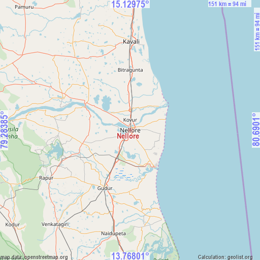
Nellore GPS coordinates[2]
14° 26' 59.712" North, 79° 59' 13.092" East
| Map corner | latitude | longitude |
|---|---|---|
| Upper-left | 15.12975°, | 79.28385° |
| Center: | 14.44992°, | 79.98697° |
| Lower-right: | 13.76801°, | 80.6901° |
| Map W x H: | 151.4×151.4 km | = 94.1×94.1mi |
| max Lat: | 34.9274° ⇑82.5% North |
| Nellore: | 14.44992° |
| min Lat: | ⇓17.5% South 8.09008° |
| min Long | Nellore | max Long |
| 68.82655° | 79.98697° | 96.81° |
| W 67.7%⇐ | ⇒32.3% E |
Elevation
Elevation of Nellore is 21 m = 69 ft, and this is 274.6 m = 901 ft below average elevation for this country.
| Max E: |
3681 m = 12077 ft | 88.6% |
| Avg. | 295.6 m = 970 ft | |
| Nellore | 21 m = 69 ft | |
Min E: |
1 m = 3 ft | 11.4% |
See also: Nellore elevation on elevation.city.
Geographical zone
Nellore is located in North Torrid zone (between Equator and Tropic of Cancer). Distance of this Northern Tropic circle is 999.2 km =620.9 mi to North.| Distance of | km | miles | from Nellore |
|---|---|---|---|
| North Pole | 8400.4 | 5219.8 | to North |
| Arctic Circle | 5794.5 | 3600.5 | to North |
| Tropic Cancer | 999.2 | 620.9 | to North |
| Equator | 1606.7 | 998.4 | to South |


Nearby cities:
15 places around Nellore: (largest is in red/bold)
• Akkarampalle
107.9 km =67 mi,  214°
214°
• Badvel
104.7 km =65.1 mi,  288°
288°
• Gūdūr
36.3 km =22.6 mi,  203°
203°
• Kandukūr
85.6 km =53.2 mi,  354°
354°
• Kovūr
5.6 km =3.5 mi,  358°
358°
• Kāvali
51.9 km =32.2 mi,  0°
0°
• Nāgireddipalli
97.5 km =60.6 mi,  258°
258°
• Nāyudupet
61.1 km =38 mi,  189°
189°
• Renigunta
102.5 km =63.7 mi, 209°
• Rāzampeta
93.6 km =58.2 mi,  252°
252°
• Singarāyakonda
86.9 km =54 mi, 2°
• Sūlūru
83.4 km =51.8 mi,  177°
177°
• Tirupati
109.3 km =67.9 mi, 214°
• Vadlapūdi
25 km =15.5 mi,  231°
231°
• Venkatagiri
69.9 km =43.4 mi,  218°
218°
Sources, notices
• [Note1] Compared only with cities in India existing in our database
• [Src1] Map data: © OpenStreetMap contributors (CC-BY-SA)
• [Src2] Other city data from geonames.org with taken over terms of usage.
• [Src3] Geographical zone / Annual Mean Temperature by Robert A. Rohde @ Wikipedia
