Kovūr geodata
Kovūr (Andhra Pradesh) is a populated place; located in India in Asia/Kolkata (GMT+5.5) time zone. With population of 35,600 people, there are 1217 cities with bigger population in this country. Compared to other cities in India, 82.4% of cities are located further ↑North; 67.6% of cities are located further ←West and 87.6% of cities have higher elevation than Kovūr. Note1


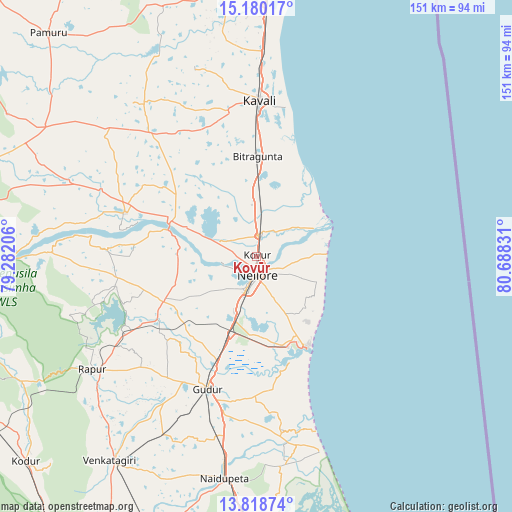
Kovūr GPS coordinates[2]
14° 30' 1.8" North, 79° 59' 6.648" East
| Map corner | latitude | longitude |
|---|---|---|
| Upper-left | 15.18017°, | 79.28206° |
| Center: | 14.5005°, | 79.98518° |
| Lower-right: | 13.81874°, | 80.68831° |
| Map W x H: | 151.4×151.4 km | = 94.1×94.1mi |
| max Lat: | 34.9274° ⇑82.4% North |
| Kovūr: | 14.5005° |
| min Lat: | ⇓17.6% South 8.09008° |
| min Long | Kovūr | max Long |
| 68.82655° | 79.98518° | 96.81° |
| W 67.6%⇐ | ⇒32.4% E |
Elevation
Elevation of Kovūr is 23 m = 75 ft, and this is 272.6 m = 894 ft below average elevation for this country.
| Max E: |
3681 m = 12077 ft | 87.6% |
| Avg. | 295.6 m = 970 ft | |
| Kovūr | 23 m = 75 ft | |
Min E: |
1 m = 3 ft | 12.4% |
See also: India elevation on elevation.city.
Geographical zone
Kovūr is located in North Torrid zone (between Equator and Tropic of Cancer). Distance of this Northern Tropic circle is 993.6 km =617.4 mi to North.| Distance of | km | miles | from Kovūr |
|---|---|---|---|
| North Pole | 8394.8 | 5216.3 | to North |
| Arctic Circle | 5788.9 | 3597.1 | to North |
| Tropic Cancer | 993.6 | 617.4 | to North |
| Equator | 1612.3 | 1001.8 | to South |


Nearby cities:
15 places around Kovūr: (largest is in red/bold)
• Akkarampalle
112.5 km =69.9 mi,  212°
212°
• Badvel
102.9 km =63.9 mi,  285°
285°
• Gūdūr
41.4 km =25.7 mi,  200°
200°
• Kandukūr
80 km =49.7 mi,  353°
353°
• Kāvali
46.2 km =28.7 mi,  1°
1°
• Nellore
5.6 km =3.5 mi,  178°
178°
• Nāgireddipalli
98.6 km =61.3 mi,  254°
254°
• Nāyudupet
66.7 km =41.4 mi,  188°
188°
• Ongole
111.7 km =69.4 mi, 3°
• Renigunta
107.3 km =66.7 mi, 208°
• Rāzampeta
95.2 km =59.2 mi, 249°
• Singarāyakonda
81.3 km =50.5 mi, 3°
• Sūlūru
89.1 km =55.4 mi, 177°
• Vadlapūdi
28.7 km =17.8 mi,  222°
222°
• Venkatagiri
74.3 km =46.2 mi, 215°
Sources, notices
• [Note1] Compared only with cities in India existing in our database
• [Src1] Map data: © OpenStreetMap contributors (CC-BY-SA)
• [Src2] Other city data from geonames.org with taken over terms of usage.
• [Src3] Geographical zone / Annual Mean Temperature by Robert A. Rohde @ Wikipedia
