Gondal geodata
Gondal (Gujarat) is a populated place; located in India in Asia/Kolkata (GMT+5.5) time zone. With population of 101,801 people, there are 430 cities with bigger population in this country. Compared to other cities in India, 56.8% of cities are located further ↑North; 98.7% of cities are located further →East and 61.8% of cities have higher elevation than Gondal. Note1


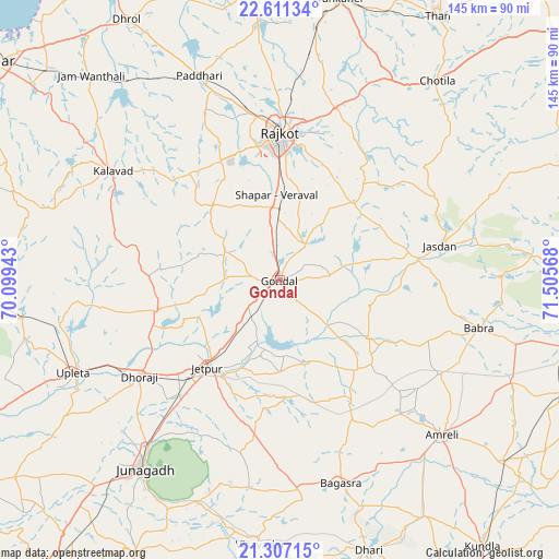
Gondal GPS coordinates[2]
21° 57' 38.664" North, 70° 48' 9.18" East
| Map corner | latitude | longitude |
|---|---|---|
| Upper-left | 22.61134°, | 70.09943° |
| Center: | 21.96074°, | 70.80255° |
| Lower-right: | 21.30715°, | 71.50568° |
| Map W x H: | 145×145 km | = 90.1×90.1mi |
| max Lat: | 34.9274° ⇑56.8% North |
| Gondal: | 21.96074° |
| min Lat: | ⇓43.2% South 8.09008° |
| min Long | Gondal | max Long |
| 68.82655° | 70.80255° | 96.81° |
| W 1.3%⇐ | ⇒98.7% E |
Elevation
Elevation of Gondal is 139 m = 456 ft, and this is 156.6 m = 514 ft below average elevation for this country.
| Max E: |
3681 m = 12077 ft | 61.8% |
| Avg. | 295.6 m = 970 ft | |
| Gondal | 139 m = 456 ft | |
Min E: |
1 m = 3 ft | 38.2% |
See also: Gondal elevation on elevation.city.
Geographical zone
Gondal is located in North Torrid zone (between Equator and Tropic of Cancer). Distance of this Northern Tropic circle is 164.1 km =102 mi to North.| Distance of | km | miles | from Gondal |
|---|---|---|---|
| North Pole | 7565.3 | 4700.9 | to North |
| Arctic Circle | 4959.4 | 3081.6 | to North |
| Tropic Cancer | 164.1 | 102 | to North |
| Equator | 2441.8 | 1517.3 | to South |


Nearby cities:
15 places around Gondal: (largest is in red/bold)
• Amreli
58.3 km =36.2 mi,  133°
133°
• Bagasra
55 km =34.2 mi,  163°
163°
• Bhāyāvadar
58.4 km =36.3 mi,  258°
258°
• Bilkha
61.4 km =38.2 mi,  199°
199°
• Bābra
53.4 km =33.2 mi,  103°
103°
• Dhorāji
44.3 km =27.5 mi,  235°
235°
• Jasdan
42.6 km =26.5 mi,  78°
78°
• Jetalsar
36.4 km =22.6 mi,  219°
219°
• Jetpur
29.4 km =18.3 mi, 218°
• Jūnāgadh
60.5 km =37.6 mi, 215°
• Kālāvad
51.2 km =31.8 mi,  302°
302°
• Paddhari
56.8 km =35.3 mi,  338°
338°
• Rājkot
36.8 km =22.9 mi,  358°
358°
• Shāhpur
22 km =13.7 mi,  351°
351°
• Upleta
59 km =36.7 mi,  245°
245°
Sources, notices
• [Note1] Compared only with cities in India existing in our database
• [Src1] Map data: © OpenStreetMap contributors (CC-BY-SA)
• [Src2] Other city data from geonames.org with taken over terms of usage.
• [Src3] Geographical zone / Annual Mean Temperature by Robert A. Rohde @ Wikipedia
