Jasdan geodata
Jasdan (Gujarat) is a populated place; located in India in Asia/Kolkata (GMT+5.5) time zone. With population of 43,861 people, there are 1006 cities with bigger population in this country. Compared to other cities in India, 56.5% of cities are located further ↑North; 98.3% of cities are located further →East and 50.4% of cities have lower elevation than Jasdan. Note1


Jasdan GPS coordinates[2]
22° 2' 13.524" North, 71° 12' 28.584" East
| Map corner | latitude | longitude |
|---|---|---|
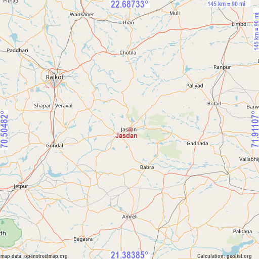
| Upper-left | 22.68733°, | 70.50482° |
| Center: | 22.03709°, | 71.20794° |
| Lower-right: | 21.38385°, | 71.91107° |
| Map W x H: | 144.9×144.9 km | = 90×90mi |
| max Lat: | 34.9274° ⇑56.5% North |
| Jasdan: | 22.03709° |
| min Lat: | ⇓43.5% South 8.09008° |
| min Long | Jasdan | max Long |
| 68.82655° | 71.20794° | 96.81° |
| W 1.7%⇐ | ⇒98.3% E |
Elevation
Elevation of Jasdan is 204 m = 669 ft, and this is 91.6 m = 301 ft below average elevation for this country.
| Max E: |
3681 m = 12077 ft | 49.6% |
| Avg. | 295.6 m = 970 ft | |
| Jasdan | 204 m = 669 ft | |
Min E: |
1 m = 3 ft | 50.4% |
See also: Jasdan elevation on elevation.city.
Geographical zone
Jasdan is located in North Torrid zone (between Equator and Tropic of Cancer). Distance of this Northern Tropic circle is 155.6 km =96.7 mi to North.| Distance of | km | miles | from Jasdan |
|---|---|---|---|
| North Pole | 7556.8 | 4695.6 | to North |
| Arctic Circle | 4950.9 | 3076.3 | to North |
| Tropic Cancer | 155.6 | 96.7 | to North |
| Equator | 2450.3 | 1522.5 | to South |


Nearby cities:
15 places around Jasdan: (largest is in red/bold)
• Amreli
48.6 km =30.2 mi,  179°
179°
• Botād
49.5 km =30.8 mi,  72°
72°
• Bābra
23.5 km =14.6 mi,  154°
154°
• Chotila
43 km =26.7 mi,  358°
358°
• Dhola
60.8 km =37.8 mi,  106°
106°
• Dāmnagar
49.9 km =31 mi,  140°
140°
• Gadhada
38.9 km =24.2 mi,  101°
101°
• Gondal
42.6 km =26.5 mi,  258°
258°
• Lāthi
39.6 km =24.6 mi, 151°
• Pāliyād
43.8 km =27.2 mi,  55°
55°
• Rājkot
51.2 km =31.8 mi,  303°
303°
• Shāhpur
47 km =29.2 mi,  286°
286°
• Sāyla
63.6 km =39.5 mi,  26°
26°
• Thān
59.7 km =37.1 mi, 359°
• Vinchia
26.1 km =16.2 mi,  42°
42°
Sources, notices
• [Note1] Compared only with cities in India existing in our database
• [Src1] Map data: © OpenStreetMap contributors (CC-BY-SA)
• [Src2] Other city data from geonames.org with taken over terms of usage.
• [Src3] Geographical zone / Annual Mean Temperature by Robert A. Rohde @ Wikipedia
