Rājkot geodata
Rājkot (Gujarat) is a populated place; located in India in Asia/Kolkata (GMT+5.5) time zone. With population of 1,177,362 people, there are 32 cities with bigger population in this country. Compared to other cities in India, 54.6% of cities are located further ↑North; 98.7% of cities are located further →East and 61.5% of cities have higher elevation than Rājkot. Note1


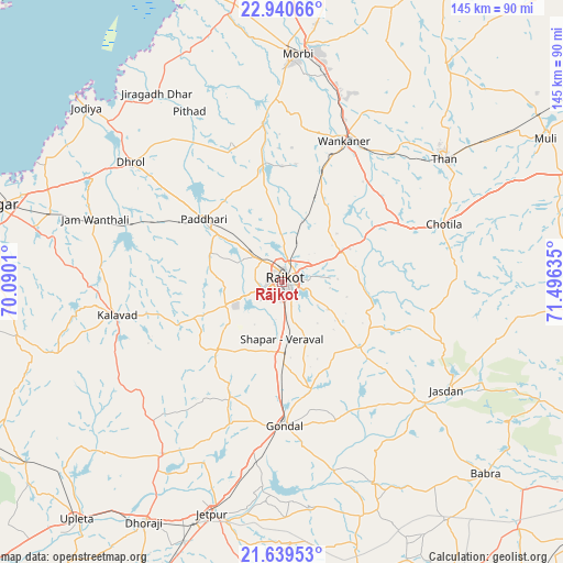
Rājkot GPS coordinates[2]
22° 17' 29.796" North, 70° 47' 35.592" East
| Map corner | latitude | longitude |
|---|---|---|
| Upper-left | 22.94066°, | 70.0901° |
| Center: | 22.29161°, | 70.79322° |
| Lower-right: | 21.63953°, | 71.49635° |
| Map W x H: | 144.7×144.7 km | = 89.9×89.9mi |
| max Lat: | 34.9274° ⇑54.6% North |
| Rājkot: | 22.29161° |
| min Lat: | ⇓45.4% South 8.09008° |
| min Long | Rājkot | max Long |
| 68.82655° | 70.79322° | 96.81° |
| W 1.3%⇐ | ⇒98.7% E |
Elevation
Elevation of Rājkot is 140 m = 459 ft, and this is 155.6 m = 510 ft below average elevation for this country.
| Max E: |
3681 m = 12077 ft | 61.5% |
| Avg. | 295.6 m = 970 ft | |
| Rājkot | 140 m = 459 ft | |
Min E: |
1 m = 3 ft | 38.5% |
See also: Rājkot elevation on elevation.city.
Geographical zone
Rājkot is located in North Torrid zone (between Equator and Tropic of Cancer). Distance of this Northern Tropic circle is 127.3 km =79.1 mi to North.| Distance of | km | miles | from Rājkot |
|---|---|---|---|
| North Pole | 7528.5 | 4678 | to North |
| Arctic Circle | 4922.6 | 3058.8 | to North |
| Tropic Cancer | 127.3 | 79.1 | to North |
| Equator | 2478.6 | 1540.1 | to South |


Nearby cities:
15 places around Rājkot: (largest is in red/bold)
• Chotila
44 km =27.3 mi,  70°
70°
• Dhrol
49.3 km =30.6 mi,  308°
308°
• Gondal
36.8 km =22.9 mi,  178°
178°
• Jasdan
51.2 km =31.8 mi,  123°
123°
• Jetalsar
68.5 km =42.6 mi,  198°
198°
• Jetpur
62.2 km =38.6 mi, 196°
• Jodiya Bandar
70.5 km =43.8 mi, 312°
• Kālāvad
43.2 km =26.8 mi,  257°
257°
• Morbi
58.6 km =36.4 mi,  4°
4°
• Paddhari
25.5 km =15.8 mi, 309°
• Shāhpur
15.2 km =9.4 mi,  188°
188°
• Tankāra
40.8 km =25.4 mi,  353°
353°
• Thān
52.3 km =32.5 mi,  53°
53°
• Vinchia
61 km =37.9 mi,  98°
98°
• Wānkāner
38.8 km =24.1 mi,  23°
23°
Sources, notices
• [Note1] Compared only with cities in India existing in our database
• [Src1] Map data: © OpenStreetMap contributors (CC-BY-SA)
• [Src2] Other city data from geonames.org with taken over terms of usage.
• [Src3] Geographical zone / Annual Mean Temperature by Robert A. Rohde @ Wikipedia
