Shāhpur geodata
Shāhpur (Gujarat) is a populated place; located in India in Asia/Kolkata (GMT+5.5) time zone. With population of 12,867 people, there are 2665 cities with bigger population in this country. Compared to other cities in India, 55.8% of cities are located further ↑North; 98.7% of cities are located further →East and 53.5% of cities have higher elevation than Shāhpur. Note1


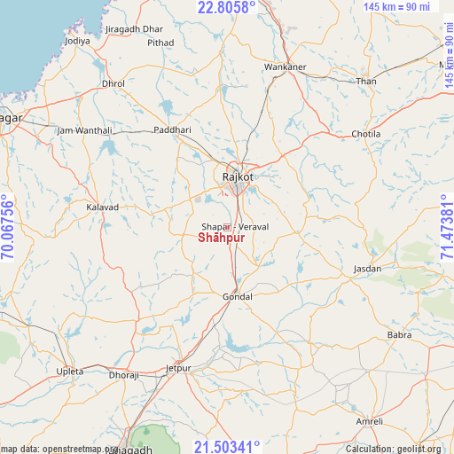
Shāhpur GPS coordinates[2]
22° 9' 21.996" North, 70° 46' 14.448" East
| Map corner | latitude | longitude |
|---|---|---|
| Upper-left | 22.8058°, | 70.06756° |
| Center: | 22.15611°, | 70.77068° |
| Lower-right: | 21.50341°, | 71.47381° |
| Map W x H: | 144.8×144.8 km | = 90×90mi |
| max Lat: | 34.9274° ⇑55.8% North |
| Shāhpur: | 22.15611° |
| min Lat: | ⇓44.2% South 8.09008° |
| min Long | Shāhpur | max Long |
| 68.82655° | 70.77068° | 96.81° |
| W 1.3%⇐ | ⇒98.7% E |
Elevation
Elevation of Shāhpur is 182 m = 597 ft, and this is 113.6 m = 373 ft below average elevation for this country.
| Max E: |
3681 m = 12077 ft | 53.5% |
| Avg. | 295.6 m = 970 ft | |
| Shāhpur | 182 m = 597 ft | |
Min E: |
1 m = 3 ft | 46.5% |
See also: India elevation on elevation.city.
Geographical zone
Shāhpur is located in North Torrid zone (between Equator and Tropic of Cancer). Distance of this Northern Tropic circle is 142.4 km =88.5 mi to North.| Distance of | km | miles | from Shāhpur |
|---|---|---|---|
| North Pole | 7543.5 | 4687.3 | to North |
| Arctic Circle | 4937.6 | 3068.1 | to North |
| Tropic Cancer | 142.4 | 88.5 | to North |
| Equator | 2463.5 | 1530.7 | to South |


Nearby cities:
15 places around Shāhpur: (largest is in red/bold)
• Bhāyāvadar
63.4 km =39.4 mi,  238°
238°
• Chotila
52.9 km =32.9 mi,  55°
55°
• Dhorāji
57.5 km =35.7 mi,  215°
215°
• Dhrol
58.4 km =36.3 mi,  321°
321°
• Gondal
22 km =13.7 mi,  171°
171°
• Jasdan
47 km =29.2 mi,  106°
106°
• Jetalsar
53.6 km =33.3 mi,  201°
201°
• Jetpur
47.1 km =29.3 mi, 198°
• Kālāvad
40.3 km =25 mi,  278°
278°
• Paddhari
35.7 km =22.2 mi,  330°
330°
• Rājkot
15.2 km =9.4 mi,  8°
8°
• Tankāra
55.6 km =34.5 mi,  357°
357°
• Thān
64.1 km =39.8 mi,  43°
43°
• Vinchia
63 km =39.1 mi,  84°
84°
• Wānkāner
53.7 km =33.4 mi,  19°
19°
Sources, notices
• [Note1] Compared only with cities in India existing in our database
• [Src1] Map data: © OpenStreetMap contributors (CC-BY-SA)
• [Src2] Other city data from geonames.org with taken over terms of usage.
• [Src3] Geographical zone / Annual Mean Temperature by Robert A. Rohde @ Wikipedia
