Gandhinagar geodata
Gandhinagar (Gujarat) is a seat of a first-order administrative division; located in India in Asia/Kolkata (GMT+5.5) time zone. With population of 195,985 people, there are 218 cities with bigger population in this country. Compared to other cities in India, 53.1% of cities are located further ↓South; 96.4% of cities are located further →East and 78.3% of cities have higher elevation than Gandhinagar. Note1


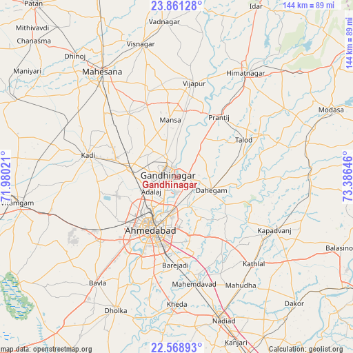
Gandhinagar GPS coordinates[2]
23° 13' 0.012" North, 72° 40' 59.988" East
| Map corner | latitude | longitude |
|---|---|---|
| Upper-left | 23.86128°, | 71.98021° |
| Center: | 23.21667°, | 72.68333° |
| Lower-right: | 22.56893°, | 73.38646° |
| Map W x H: | 143.7×143.7 km | = 89.3×89.3mi |
| max Lat: | 34.9274° ⇑46.9% North |
| Gandhinagar: | 23.21667° |
| min Lat: | ⇓53.1% South 8.09008° |
| min Long | Gandhinagar | max Long |
| 68.82655° | 72.68333° | 96.81° |
| W 3.6%⇐ | ⇒96.4% E |
Elevation
Elevation of Gandhinagar is 54 m = 177 ft, and this is 241.6 m = 793 ft below average elevation for this country.
| Max E: |
3681 m = 12077 ft | 78.3% |
| Avg. | 295.6 m = 970 ft | |
| Gandhinagar | 54 m = 177 ft | |
Min E: |
1 m = 3 ft | 21.7% |
See also: Gandhinagar elevation on elevation.city.
Geographical zone
Gandhinagar is located in North Torrid zone (between Equator and Tropic of Cancer). Distance of this Northern Tropic circle is 24.5 km =15.2 mi to North.| Distance of | km | miles | from Gandhinagar |
|---|---|---|---|
| North Pole | 7425.6 | 4614.1 | to North |
| Arctic Circle | 4819.7 | 2994.8 | to North |
| Tropic Cancer | 24.5 | 15.2 | to North |
| Equator | 2581.5 | 1604.1 | to South |


Nearby cities:
15 places around Gandhinagar: (largest is in red/bold)
• Adalaj
12 km =7.5 mi,  240°
240°
• Ahmedabad
23.4 km =14.5 mi,  204°
204°
• Chhala
13.7 km =8.5 mi,  42°
42°
• Dahegām
15.1 km =9.4 mi,  110°
110°
• Himatnagar
51.4 km =31.9 mi,  34°
34°
• Jhulasan
24.8 km =15.4 mi,  300°
300°
• Kadi
36.9 km =22.9 mi,  284°
284°
• Kapadvanj
45.1 km =28 mi,  118°
118°
• Mahemdāvād
44.3 km =27.5 mi,  170°
170°
• Mahudha
51.3 km =31.9 mi,  149°
149°
• Mānsa
23.4 km =14.5 mi,  353°
353°
• Naroda
16.5 km =10.3 mi,  189°
189°
• Sarkhej
31.9 km =19.8 mi,  215°
215°
• Sānand
39.7 km =24.7 mi,  231°
231°
• Vijāpur
39 km =24.2 mi,  9°
9°
Sources, notices
• [Note1] Compared only with cities in India existing in our database
• [Src1] Map data: © OpenStreetMap contributors (CC-BY-SA)
• [Src2] Other city data from geonames.org with taken over terms of usage.
• [Src3] Geographical zone / Annual Mean Temperature by Robert A. Rohde @ Wikipedia
