Himatnagar geodata
Himatnagar (Gujarat) is a seat of a second-order administrative division; located in India in Asia/Kolkata (GMT+5.5) time zone. With population of 60,634 people, there are 723 cities with bigger population in this country. Compared to other cities in India, 55.4% of cities are located further ↓South; 94.8% of cities are located further →East and 60.8% of cities have higher elevation than Himatnagar. Note1


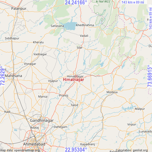
Himatnagar GPS coordinates[2]
23° 35' 56.148" North, 72° 57' 57.672" East
| Map corner | latitude | longitude |
|---|---|---|
| Upper-left | 24.24166°, | 72.2629° |
| Center: | 23.59893°, | 72.96602° |
| Lower-right: | 22.95304°, | 73.66915° |
| Map W x H: | 143.3×143.3 km | = 89×89mi |
| max Lat: | 34.9274° ⇑44.6% North |
| Himatnagar: | 23.59893° |
| min Lat: | ⇓55.4% South 8.09008° |
| min Long | Himatnagar | max Long |
| 68.82655° | 72.96602° | 96.81° |
| W 5.2%⇐ | ⇒94.8% E |
Elevation
Elevation of Himatnagar is 144 m = 472 ft, and this is 151.6 m = 497 ft below average elevation for this country.
| Max E: |
3681 m = 12077 ft | 60.8% |
| Avg. | 295.6 m = 970 ft | |
| Himatnagar | 144 m = 472 ft | |
Min E: |
1 m = 3 ft | 39.2% |
See also: Himatnagar elevation on elevation.city.
Geographical zone
Himatnagar is located in North temperate zone (between Tropic of Cancer and the Arctic Circle). Distance of this Northern Tropic circle is 18 km =11.2 mi to South.| Distance of | km | miles | from Himatnagar |
|---|---|---|---|
| North Pole | 7383.1 | 4587.6 | to North |
| Arctic Circle | 4777.2 | 2968.4 | to North |
| Tropic Cancer | 18 | 11.2 | to South |
| Equator | 2624 | 1630.5 | to South |


Nearby cities:
15 places around Himatnagar: (largest is in red/bold)
• Adalaj
62.3 km =38.7 mi,  219°
219°
• Chhala
37.8 km =23.5 mi,  211°
211°
• Dahegām
50 km =31.1 mi,  197°
197°
• Gandhinagar
51.4 km =31.9 mi, 214°
• Jhulasan
58.6 km =36.4 mi,  239°
239°
• Khedbrahma
48.6 km =30.2 mi,  9°
9°
• Kherālu
47.6 km =29.6 mi,  312°
312°
• Meghraj
56.9 km =35.4 mi,  101°
101°
• Modāsa
37.1 km =23.1 mi,  114°
114°
• Mālpur
57.5 km =35.7 mi,  117°
117°
• Mānsa
36.9 km =22.9 mi, 238°
• Unjha
62.8 km =39 mi,  291°
291°
• Vadnagar
39.3 km =24.4 mi,  301°
301°
• Vijāpur
22.5 km =14 mi,  259°
259°
• Visnagar
43.6 km =27.1 mi,  284°
284°
Sources, notices
• [Note1] Compared only with cities in India existing in our database
• [Src1] Map data: © OpenStreetMap contributors (CC-BY-SA)
• [Src2] Other city data from geonames.org with taken over terms of usage.
• [Src3] Geographical zone / Annual Mean Temperature by Robert A. Rohde @ Wikipedia
