Vijāpur geodata
Vijāpur (Gujarat) is a populated place; located in India in Asia/Kolkata (GMT+5.5) time zone. With population of 24,297 people, there are 1748 cities with bigger population in this country. Compared to other cities in India, 55.2% of cities are located further ↓South; 96.2% of cities are located further →East and 64.2% of cities have higher elevation than Vijāpur. Note1


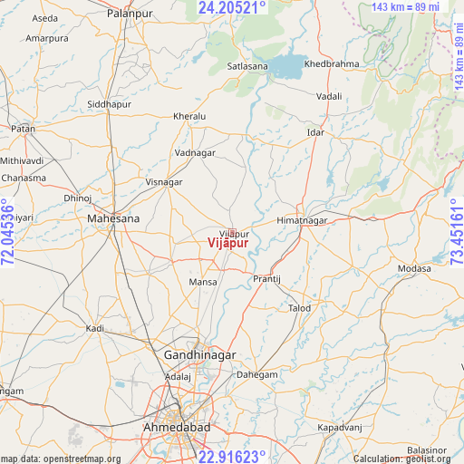
Vijāpur GPS coordinates[2]
23° 33' 44.28" North, 72° 44' 54.528" East
| Map corner | latitude | longitude |
|---|---|---|
| Upper-left | 24.20521°, | 72.04536° |
| Center: | 23.5623°, | 72.74848° |
| Lower-right: | 22.91623°, | 73.45161° |
| Map W x H: | 143.3×143.3 km | = 89×89mi |
| max Lat: | 34.9274° ⇑44.8% North |
| Vijāpur: | 23.5623° |
| min Lat: | ⇓55.2% South 8.09008° |
| min Long | Vijāpur | max Long |
| 68.82655° | 72.74848° | 96.81° |
| W 3.8%⇐ | ⇒96.2% E |
Elevation
Elevation of Vijāpur is 126 m = 413 ft, and this is 169.6 m = 556 ft below average elevation for this country.
| Max E: |
3681 m = 12077 ft | 64.2% |
| Avg. | 295.6 m = 970 ft | |
| Vijāpur | 126 m = 413 ft | |
Min E: |
1 m = 3 ft | 35.8% |
See also: India elevation on elevation.city.
Geographical zone
Vijāpur is located in North temperate zone (between Tropic of Cancer and the Arctic Circle). Distance of this Northern Tropic circle is 14 km =8.7 mi to South.| Distance of | km | miles | from Vijāpur |
|---|---|---|---|
| North Pole | 7387.2 | 4590.2 | to North |
| Arctic Circle | 4781.3 | 2971 | to North |
| Tropic Cancer | 14 | 8.7 | to South |
| Equator | 2619.9 | 1627.9 | to South |


Nearby cities:
15 places around Vijāpur: (largest is in red/bold)
• Adalaj
47.4 km =29.5 mi,  201°
201°
• Chhala
28.4 km =17.6 mi,  174°
174°
• Dahegām
44.4 km =27.6 mi, 170°
• Gandhinagar
39 km =24.2 mi,  189°
189°
• Himatnagar
22.5 km =14 mi,  79°
79°
• Jhulasan
38.3 km =23.8 mi,  227°
227°
• Kadi
51.5 km =32 mi,  235°
235°
• Kherālu
38.3 km =23.8 mi,  339°
339°
• Modāsa
57.2 km =35.5 mi,  101°
101°
• Mānsa
17.8 km =11.1 mi,  211°
211°
• Naroda
55.5 km =34.5 mi, 189°
• Siddhapur
55 km =34.2 mi,  315°
315°
• Unjha
45.2 km =28.1 mi,  306°
306°
• Vadnagar
27.3 km =17 mi, 335°
• Visnagar
25.1 km =15.6 mi, 307°
Sources, notices
• [Note1] Compared only with cities in India existing in our database
• [Src1] Map data: © OpenStreetMap contributors (CC-BY-SA)
• [Src2] Other city data from geonames.org with taken over terms of usage.
• [Src3] Geographical zone / Annual Mean Temperature by Robert A. Rohde @ Wikipedia
