Mānsa geodata
Mānsa (Gujarat) is a populated place; located in India in Asia/Kolkata (GMT+5.5) time zone. With population of 29,551 people, there are 1471 cities with bigger population in this country. Compared to other cities in India, 54.4% of cities are located further ↓South; 96.5% of cities are located further →East and 67.2% of cities have higher elevation than Mānsa. Note1


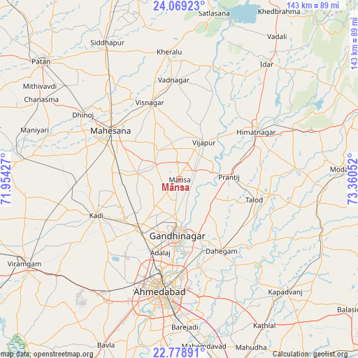
Mānsa GPS coordinates[2]
23° 25' 32.304" North, 72° 39' 26.604" East
| Map corner | latitude | longitude |
|---|---|---|
| Upper-left | 24.06923°, | 71.95427° |
| Center: | 23.42564°, | 72.65739° |
| Lower-right: | 22.77891°, | 73.36052° |
| Map W x H: | 143.5×143.5 km | = 89.2×89.2mi |
| max Lat: | 34.9274° ⇑45.6% North |
| Mānsa: | 23.42564° |
| min Lat: | ⇓54.4% South 8.09008° |
| min Long | Mānsa | max Long |
| 68.82655° | 72.65739° | 96.81° |
| W 3.5%⇐ | ⇒96.5% E |
Elevation
Elevation of Mānsa is 106 m = 348 ft, and this is 189.6 m = 622 ft below average elevation for this country.
| Max E: |
3681 m = 12077 ft | 67.2% |
| Avg. | 295.6 m = 970 ft | |
| Mānsa | 106 m = 348 ft | |
Min E: |
1 m = 3 ft | 32.8% |
See also: India elevation on elevation.city.
Geographical zone
Mānsa is located in North Torrid zone (between Equator and Tropic of Cancer). Distance of this Northern Tropic circle is 1.2 km =0.7 mi to North.| Distance of | km | miles | from Mānsa |
|---|---|---|---|
| North Pole | 7402.4 | 4599.6 | to North |
| Arctic Circle | 4796.5 | 2980.4 | to North |
| Tropic Cancer | 1.2 | 0.7 | to North |
| Equator | 2604.7 | 1618.5 | to South |


Nearby cities:
15 places around Mānsa: (largest is in red/bold)
• Adalaj
30.1 km =18.7 mi,  195°
195°
• Ahmedabad
45 km =28 mi,  189°
189°
• Chhala
17.7 km =11 mi,  137°
137°
• Dahegām
33.1 km =20.6 mi,  149°
149°
• Gandhinagar
23.4 km =14.5 mi,  173°
173°
• Himatnagar
36.9 km =22.9 mi,  58°
58°
• Jhulasan
21.7 km =13.5 mi,  240°
240°
• Kadi
35.9 km =22.3 mi,  246°
246°
• Kherālu
51.3 km =31.9 mi,  355°
355°
• Naroda
39.5 km =24.5 mi,  180°
180°
• Sarkhej
51.7 km =32.1 mi, 197°
• Unjha
50 km =31.1 mi,  327°
327°
• Vadnagar
40.1 km =24.9 mi, 357°
• Vijāpur
17.8 km =11.1 mi,  31°
31°
• Visnagar
32.2 km =20 mi,  340°
340°
Sources, notices
• [Note1] Compared only with cities in India existing in our database
• [Src1] Map data: © OpenStreetMap contributors (CC-BY-SA)
• [Src2] Other city data from geonames.org with taken over terms of usage.
• [Src3] Geographical zone / Annual Mean Temperature by Robert A. Rohde @ Wikipedia
