Farrukhābād geodata
Farrukhābād (Uttar Pradesh) is a populated place; located in India in Asia/Kolkata (GMT+5.5) time zone. With population of 241,152 people, there are 178 cities with bigger population in this country. Compared to other cities in India, 81.1% of cities are located further ↓South; 64.5% of cities are located further ←West and 58.4% of cities have higher elevation than Farrukhābād. Note1


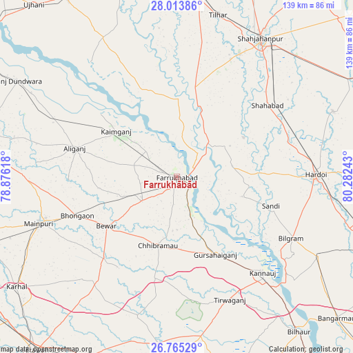
Farrukhābād GPS coordinates[2]
27° 23' 28.824" North, 79° 34' 45.48" East
| Map corner | latitude | longitude |
|---|---|---|
| Upper-left | 28.01386°, | 78.87618° |
| Center: | 27.39134°, | 79.5793° |
| Lower-right: | 26.76529°, | 80.28243° |
| Map W x H: | 138.8×138.8 km | = 86.2×86.2mi |
| max Lat: | 34.9274° ⇑18.9% North |
| Farrukhābād: | 27.39134° |
| min Lat: | ⇓81.1% South 8.09008° |
| min Long | Farrukhābād | max Long |
| 68.82655° | 79.5793° | 96.81° |
| W 64.5%⇐ | ⇒35.5% E |
Elevation
Elevation of Farrukhābād is 156 m = 512 ft, and this is 139.6 m = 458 ft below average elevation for this country.
| Max E: |
3681 m = 12077 ft | 58.4% |
| Avg. | 295.6 m = 970 ft | |
| Farrukhābād | 156 m = 512 ft | |
Min E: |
1 m = 3 ft | 41.6% |
See also: Farrukhābād elevation on elevation.city.
Geographical zone
Farrukhābād is located in North temperate zone (between Tropic of Cancer and the Arctic Circle). Distance of this Northern Tropic circle is 439.7 km =273.2 mi to South.| Distance of | km | miles | from Farrukhābād |
|---|---|---|---|
| North Pole | 6961.4 | 4325.6 | to North |
| Arctic Circle | 4355.5 | 2706.4 | to North |
| Tropic Cancer | 439.7 | 273.2 | to South |
| Equator | 3045.6 | 1892.4 | to South |


Nearby cities:
15 places around Farrukhābād: (largest is in red/bold)
• Allāhganj
20.2 km =12.6 mi,  31°
31°
• Alīganj
41.8 km =26 mi,  285°
285°
• Bewar
33.8 km =21 mi,  235°
235°
• Chhibrāmau
28.1 km =17.5 mi,  196°
196°
• Fatehgarh
5.9 km =3.7 mi,  120°
120°
• Gursahāiganj
34.2 km =21.3 mi,  153°
153°
• Jalālābād
38 km =23.6 mi,  11°
11°
• Kaimganj
30.1 km =18.7 mi,  306°
306°
• Kamalganj
15.3 km =9.5 mi,  160°
160°
• Kampil
38.7 km =24 mi, 309°
• Muhammadābād
17.1 km =10.6 mi, 237°
• Saurikh
41.1 km =25.5 mi,  192°
192°
• Shamsābād
21.4 km =13.3 mi,  319°
319°
• Sāndi
38.5 km =23.9 mi,  107°
107°
• Tālgrām
38.8 km =24.1 mi,  169°
169°
Sources, notices
• [Note1] Compared only with cities in India existing in our database
• [Src1] Map data: © OpenStreetMap contributors (CC-BY-SA)
• [Src2] Other city data from geonames.org with taken over terms of usage.
• [Src3] Geographical zone / Annual Mean Temperature by Robert A. Rohde @ Wikipedia
