Alīganj geodata
Alīganj (Uttar Pradesh) is a populated place; located in India in Asia/Kolkata (GMT+5.5) time zone. With population of 26,652 people, there are 1602 cities with bigger population in this country. Compared to other cities in India, 81.8% of cities are located further ↓South; 60.7% of cities are located further ←West and 57.1% of cities have higher elevation than Alīganj. Note1


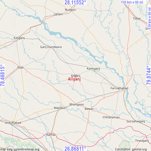
Alīganj GPS coordinates[2]
27° 29' 36.888" North, 79° 10' 16.572" East
| Map corner | latitude | longitude |
|---|---|---|
| Upper-left | 28.11552°, | 78.46815° |
| Center: | 27.49358°, | 79.17127° |
| Lower-right: | 26.86811°, | 79.8744° |
| Map W x H: | 138.7×138.7 km | = 86.2×86.2mi |
| max Lat: | 34.9274° ⇑18.2% North |
| Alīganj: | 27.49358° |
| min Lat: | ⇓81.8% South 8.09008° |
| min Long | Alīganj | max Long |
| 68.82655° | 79.17127° | 96.81° |
| W 60.7%⇐ | ⇒39.3% E |
Elevation
Elevation of Alīganj is 163 m = 535 ft, and this is 132.6 m = 435 ft below average elevation for this country.
| Max E: |
3681 m = 12077 ft | 57.1% |
| Avg. | 295.6 m = 970 ft | |
| Alīganj | 163 m = 535 ft | |
Min E: |
1 m = 3 ft | 42.9% |
See also: India elevation on elevation.city.
Geographical zone
Alīganj is located in North temperate zone (between Tropic of Cancer and the Arctic Circle). Distance of this Northern Tropic circle is 451.1 km =280.3 mi to South.| Distance of | km | miles | from Alīganj |
|---|---|---|---|
| North Pole | 6950.1 | 4318.6 | to North |
| Arctic Circle | 4344.2 | 2699.4 | to North |
| Tropic Cancer | 451.1 | 280.3 | to South |
| Equator | 3057 | 1899.5 | to South |


Nearby cities:
15 places around Alīganj: (largest is in red/bold)
• Bewar
33 km =20.5 mi,  157°
157°
• Bhongaon
26.5 km =16.5 mi,  177°
177°
• Farrukhābād
41.8 km =26 mi,  105°
105°
• Ganj Dundwāra
35 km =21.7 mi,  319°
319°
• Kaimganj
17.5 km =10.9 mi,  67°
67°
• Kakrāla
44.4 km =27.6 mi,  2°
2°
• Kampil
16.8 km =10.4 mi,  38°
38°
• Mainpuri
32.7 km =20.3 mi,  205°
205°
• Muhammadābād
33 km =20.5 mi,  128°
128°
• Nagla Panchi
42.6 km =26.5 mi,  186°
186°
• Patiāli
27.8 km =17.3 mi, 322°
• Sakīt
39.2 km =24.4 mi,  260°
260°
• Shamsābād
26.7 km =16.6 mi,  79°
79°
• Sidhpura
33.6 km =20.9 mi,  297°
297°
• Usehat
34.5 km =21.4 mi,  10°
10°
Sources, notices
• [Note1] Compared only with cities in India existing in our database
• [Src1] Map data: © OpenStreetMap contributors (CC-BY-SA)
• [Src2] Other city data from geonames.org with taken over terms of usage.
• [Src3] Geographical zone / Annual Mean Temperature by Robert A. Rohde @ Wikipedia
