Kampil geodata
Kampil (Uttar Pradesh) is a populated place; located in India in Asia/Kolkata (GMT+5.5) time zone. With population of 9,200 people, there are 3019 cities with bigger population in this country. Compared to other cities in India, 82.6% of cities are located further ↓South; 61.6% of cities are located further ←West and 57.4% of cities have higher elevation than Kampil. Note1


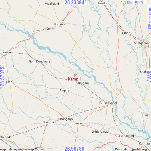
Kampil GPS coordinates[2]
27° 36' 45.648" North, 79° 16' 36.732" East
| Map corner | latitude | longitude |
|---|---|---|
| Upper-left | 28.23394°, | 78.57375° |
| Center: | 27.61268°, | 79.27687° |
| Lower-right: | 26.98788°, | 79.98° |
| Map W x H: | 138.5×138.6 km | = 86.1×86.1mi |
| max Lat: | 34.9274° ⇑17.4% North |
| Kampil: | 27.61268° |
| min Lat: | ⇓82.6% South 8.09008° |
| min Long | Kampil | max Long |
| 68.82655° | 79.27687° | 96.81° |
| W 61.6%⇐ | ⇒38.4% E |
Elevation
Elevation of Kampil is 161 m = 528 ft, and this is 134.6 m = 442 ft below average elevation for this country.
| Max E: |
3681 m = 12077 ft | 57.4% |
| Avg. | 295.6 m = 970 ft | |
| Kampil | 161 m = 528 ft | |
Min E: |
1 m = 3 ft | 42.6% |
See also: India elevation on elevation.city.
Geographical zone
Kampil is located in North temperate zone (between Tropic of Cancer and the Arctic Circle). Distance of this Northern Tropic circle is 464.3 km =288.5 mi to South.| Distance of | km | miles | from Kampil |
|---|---|---|---|
| North Pole | 6936.8 | 4310.3 | to North |
| Arctic Circle | 4330.9 | 2691.1 | to North |
| Tropic Cancer | 464.3 | 288.5 | to South |
| Equator | 3070.2 | 1907.7 | to South |


Nearby cities:
15 places around Kampil: (largest is in red/bold)
• Allāhganj
41.1 km =25.5 mi,  100°
100°
• Alīganj
16.8 km =10.4 mi,  218°
218°
• Bewar
43.9 km =27.3 mi,  177°
177°
• Bhongaon
40.9 km =25.4 mi,  193°
193°
• Farrukhābād
38.7 km =24 mi,  129°
129°
• Fatehgarh
44.6 km =27.7 mi, 128°
• Ganj Dundwāra
35.7 km =22.2 mi,  292°
292°
• Jalālābād
39.3 km =24.4 mi,  71°
71°
• Kaimganj
8.7 km =5.4 mi,  138°
138°
• Kakrāla
32.2 km =20 mi,  345°
345°
• Muhammadābād
37.1 km =23.1 mi,  155°
155°
• Patiāli
28.8 km =17.9 mi, 287°
• Shamsābād
18 km =11.2 mi,  117°
117°
• Sidhpura
40.2 km =25 mi,  273°
273°
• Usehat
21 km =13 mi, 349°
Sources, notices
• [Note1] Compared only with cities in India existing in our database
• [Src1] Map data: © OpenStreetMap contributors (CC-BY-SA)
• [Src2] Other city data from geonames.org with taken over terms of usage.
• [Src3] Geographical zone / Annual Mean Temperature by Robert A. Rohde @ Wikipedia
