Chāmpua geodata
Chāmpua (Odisha) is a populated place; located in India in Asia/Kolkata (GMT+5.5) time zone. With population of 9,487 people, there are 2995 cities with bigger population in this country. Compared to other cities in India, 56.2% of cities are located further ↑North; 86.1% of cities are located further ←West and 75.8% of cities have lower elevation than Chāmpua. Note1


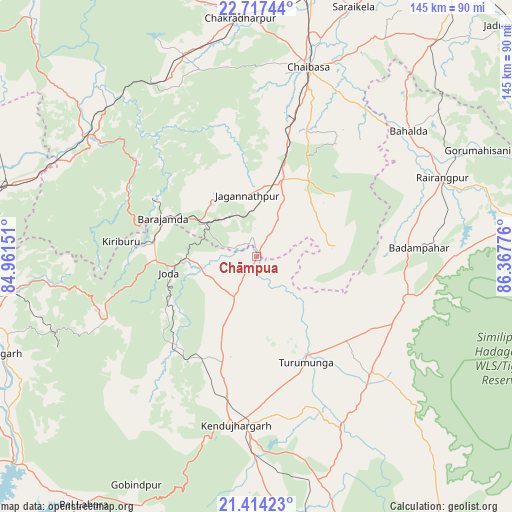
Chāmpua GPS coordinates[2]
22° 4' 2.424" North, 85° 39' 52.668" East
| Map corner | latitude | longitude |
|---|---|---|
| Upper-left | 22.71744°, | 84.96151° |
| Center: | 22.06734°, | 85.66463° |
| Lower-right: | 21.41423°, | 86.36776° |
| Map W x H: | 144.9×144.9 km | = 90×90mi |
| max Lat: | 34.9274° ⇑56.2% North |
| Chāmpua: | 22.06734° |
| min Lat: | ⇓43.8% South 8.09008° |
| min Long | Chāmpua | max Long |
| 68.82655° | 85.66463° | 96.81° |
| W 86.1%⇐ | ⇒13.9% E |
Elevation
Elevation of Chāmpua is 396 m = 1299 ft, and this is 100.4 m = 329 ft above average elevation for this country.
| Max E: |
3681 m = 12077 ft | 24.2% |
| Chāmpua | 396 m 1299 ft | |
| Avg. | 295.6 m = 970 ft | |
Min E: |
1 m = 3 ft | 75.8% |
See also: India elevation on elevation.city.
Geographical zone
Chāmpua is located in North Torrid zone (between Equator and Tropic of Cancer). Distance of this Northern Tropic circle is 152.3 km =94.6 mi to North.| Distance of | km | miles | from Chāmpua |
|---|---|---|---|
| North Pole | 7553.4 | 4693.5 | to North |
| Arctic Circle | 4947.5 | 3074.2 | to North |
| Tropic Cancer | 152.3 | 94.6 | to North |
| Equator | 2453.7 | 1524.7 | to South |


Nearby cities:
15 places around Chāmpua: (largest is in red/bold)
• Bada Barabīl
29 km =18 mi,  279°
279°
• Barbil
29.8 km =18.5 mi, 277°
• Bolānīkhodān
34.2 km =21.3 mi, 278°
• Chakradharpur
67.8 km =42.1 mi,  356°
356°
• Chiria
48.3 km =30 mi,  304°
304°
• Chāībāsa
55.5 km =34.5 mi,  14°
14°
• Gobindpur
75.6 km =47 mi,  33°
33°
• Gopināthpur
78.5 km =48.8 mi, 32°
• Gua
32.8 km =20.4 mi, 299°
• Jagannāthpur
17.3 km =10.7 mi,  351°
351°
• Kiri Buru
32.5 km =20.2 mi,  273°
273°
• Kuchaiburi
56.9 km =35.4 mi,  67°
67°
• Manoharpur
59.4 km =36.9 mi,  305°
305°
• Noāmundi
19.5 km =12.1 mi, 302°
• Saraikela
75.5 km =46.9 mi,  21°
21°
Sources, notices
• [Note1] Compared only with cities in India existing in our database
• [Src1] Map data: © OpenStreetMap contributors (CC-BY-SA)
• [Src2] Other city data from geonames.org with taken over terms of usage.
• [Src3] Geographical zone / Annual Mean Temperature by Robert A. Rohde @ Wikipedia
