Chiria geodata
Chiria (Jharkhand) is a populated place; located in India in Asia/Kolkata (GMT+5.5) time zone. With population of 3,945 people, there are 3383 cities with bigger population in this country. Compared to other cities in India, 54.3% of cities are located further ↑North; 84.9% of cities are located further ←West and 69.9% of cities have lower elevation than Chiria. Note1


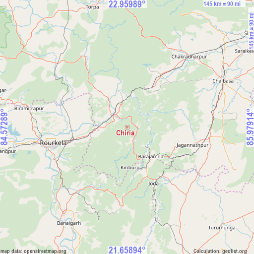
Chiria GPS coordinates[2]
22° 18' 39.348" North, 85° 16' 33.636" East
| Map corner | latitude | longitude |
|---|---|---|
| Upper-left | 22.95989°, | 84.57289° |
| Center: | 22.31093°, | 85.27601° |
| Lower-right: | 21.65894°, | 85.97914° |
| Map W x H: | 144.7×144.7 km | = 89.9×89.9mi |
| max Lat: | 34.9274° ⇑54.3% North |
| Chiria: | 22.31093° |
| min Lat: | ⇓45.7% South 8.09008° |
| min Long | Chiria | max Long |
| 68.82655° | 85.27601° | 96.81° |
| W 84.9%⇐ | ⇒15.1% E |
Elevation
Elevation of Chiria is 326 m = 1070 ft, and this is 30.4 m = 100 ft above average elevation for this country.
| Max E: |
3681 m = 12077 ft | 30.1% |
| Chiria | 326 m 1070 ft | |
| Avg. | 295.6 m = 970 ft | |
Min E: |
1 m = 3 ft | 69.9% |
See also: India elevation on elevation.city.
Geographical zone
Chiria is located in North Torrid zone (between Equator and Tropic of Cancer). Distance of this Northern Tropic circle is 125.2 km =77.8 mi to North.| Distance of | km | miles | from Chiria |
|---|---|---|---|
| North Pole | 7526.3 | 4676.6 | to North |
| Arctic Circle | 4920.4 | 3057.4 | to North |
| Tropic Cancer | 125.2 | 77.8 | to North |
| Equator | 2480.7 | 1541.4 | to South |


Nearby cities:
15 places around Chiria: (largest is in red/bold)
• Bada Barabīl
24.9 km =15.5 mi,  152°
152°
• Barbil
25.5 km =15.8 mi,  155°
155°
• Birmitrapur
53.3 km =33.1 mi,  280°
280°
• Bolānīkhodān
22.9 km =14.2 mi, 164°
• Bānposh
48.4 km =30.1 mi,  261°
261°
• Chakradharpur
54.4 km =33.8 mi,  41°
41°
• Chāmpua
48.3 km =30 mi,  124°
124°
• Chāībāsa
60.3 km =37.5 mi,  63°
63°
• Gua
15.8 km =9.8 mi,  133°
133°
• Jagannāthpur
38.7 km =24 mi,  104°
104°
• Kharsāwān
78.1 km =48.5 mi,  46°
46°
• Kiri Buru
26.4 km =16.4 mi, 163°
• Manoharpur
11.1 km =6.9 mi,  309°
309°
• Noāmundi
28.8 km =17.9 mi, 125°
• Raurkela
43.4 km =27 mi, 257°
Sources, notices
• [Note1] Compared only with cities in India existing in our database
• [Src1] Map data: © OpenStreetMap contributors (CC-BY-SA)
• [Src2] Other city data from geonames.org with taken over terms of usage.
• [Src3] Geographical zone / Annual Mean Temperature by Robert A. Rohde @ Wikipedia
