Gua geodata
Gua (Jharkhand) is a populated place; located in India in Asia/Kolkata (GMT+5.5) time zone. With population of 11,388 people, there are 2794 cities with bigger population in this country. Compared to other cities in India, 55% of cities are located further ↑North; 85.3% of cities are located further ←West and 75.4% of cities have lower elevation than Gua. Note1


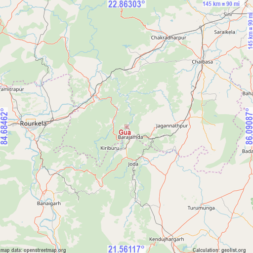
Gua GPS coordinates[2]
22° 12' 48.996" North, 85° 23' 15.864" East
| Map corner | latitude | longitude |
|---|---|---|
| Upper-left | 22.86303°, | 84.68462° |
| Center: | 22.21361°, | 85.38774° |
| Lower-right: | 21.56117°, | 86.09087° |
| Map W x H: | 144.8×144.8 km | = 90×90mi |
| max Lat: | 34.9274° ⇑55% North |
| Gua: | 22.21361° |
| min Lat: | ⇓45% South 8.09008° |
| min Long | Gua | max Long |
| 68.82655° | 85.38774° | 96.81° |
| W 85.3%⇐ | ⇒14.7% E |
Elevation
Elevation of Gua is 392 m = 1286 ft, and this is 96.4 m = 316 ft above average elevation for this country.
| Max E: |
3681 m = 12077 ft | 24.6% |
| Gua | 392 m 1286 ft | |
| Avg. | 295.6 m = 970 ft | |
Min E: |
1 m = 3 ft | 75.4% |
See also: India elevation on elevation.city.
Geographical zone
Gua is located in North Torrid zone (between Equator and Tropic of Cancer). Distance of this Northern Tropic circle is 136 km =84.5 mi to North.| Distance of | km | miles | from Gua |
|---|---|---|---|
| North Pole | 7537.1 | 4683.3 | to North |
| Arctic Circle | 4931.3 | 3064.2 | to North |
| Tropic Cancer | 136 | 84.5 | to North |
| Equator | 2469.9 | 1534.7 | to South |


Nearby cities:
15 places around Gua: (largest is in red/bold)
• Bada Barabīl
11.3 km =7 mi,  180°
180°
• Barbil
12.5 km =7.8 mi, 184°
• Birmitrapur
67.2 km =41.8 mi,  287°
287°
• Bolānīkhodān
12.4 km =7.7 mi,  205°
205°
• Bānposh
59.5 km =37 mi,  273°
273°
• Chakradharpur
57.1 km =35.5 mi,  25°
25°
• Chiria
15.8 km =9.8 mi,  313°
313°
• Chāmpua
32.8 km =20.4 mi,  119°
119°
• Chāībāsa
56.7 km =35.2 mi,  48°
48°
• Jagannāthpur
25.9 km =16.1 mi,  88°
88°
• Kiri Buru
15 km =9.3 mi,  195°
195°
• Manoharpur
26.9 km =16.7 mi, 311°
• Noāmundi
13.3 km =8.3 mi, 116°
• Raurkela
53.9 km =33.5 mi, 271°
• Saraikela
77.7 km =48.3 mi, 45°
Sources, notices
• [Note1] Compared only with cities in India existing in our database
• [Src1] Map data: © OpenStreetMap contributors (CC-BY-SA)
• [Src2] Other city data from geonames.org with taken over terms of usage.
• [Src3] Geographical zone / Annual Mean Temperature by Robert A. Rohde @ Wikipedia
