Madhyamgram geodata
Madhyamgram (West Bengal) is a populated place; located in India in Asia/Kolkata (GMT+5.5) time zone. With population of 161,126 people, there are 272 cities with bigger population in this country. Compared to other cities in India, 51.1% of cities are located further ↑North; 94% of cities are located further ←West and 96.4% of cities have higher elevation than Madhyamgram. Note1


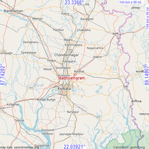
Madhyamgram GPS coordinates[2]
22° 41' 21.984" North, 88° 26' 45.384" East
| Map corner | latitude | longitude |
|---|---|---|
| Upper-left | 23.3366°, | 87.74282° |
| Center: | 22.68944°, | 88.44594° |
| Lower-right: | 22.03921°, | 89.14907° |
| Map W x H: | 144.3×144.3 km | = 89.7×89.7mi |
| max Lat: | 34.9274° ⇑51.1% North |
| Madhyamgram: | 22.68944° |
| min Lat: | ⇓48.9% South 8.09008° |
| min Long | Madhyamgram | max Long |
| 68.82655° | 88.44594° | 96.81° |
| W 94%⇐ | ⇒6% E |
Elevation
Elevation of Madhyamgram is 10 m = 33 ft, and this is 285.6 m = 937 ft below average elevation for this country.
| Max E: |
3681 m = 12077 ft | 96.4% |
| Avg. | 295.6 m = 970 ft | |
| Madhyamgram | 10 m = 33 ft | |
Min E: |
1 m = 3 ft | 3.6% |
See also: Madhyamgram elevation on elevation.city.
Geographical zone
Madhyamgram is located in North Torrid zone (between Equator and Tropic of Cancer). Distance of this Northern Tropic circle is 83.1 km =51.6 mi to North.| Distance of | km | miles | from Madhyamgram |
|---|---|---|---|
| North Pole | 7484.2 | 4650.5 | to North |
| Arctic Circle | 4878.3 | 3031.2 | to North |
| Tropic Cancer | 83.1 | 51.6 | to North |
| Equator | 2522.8 | 1567.6 | to South |


Nearby cities:
15 places around Madhyamgram: (largest is in red/bold)
• Baranagar
8.8 km =5.5 mi,  232°
232°
• Bāli
11.7 km =7.3 mi,  247°
247°
• Bārākpur
12 km =7.5 mi,  315°
315°
• Bārāsat
5.1 km =3.2 mi,  46°
46°
• Chakapara
11.8 km =7.3 mi,  237°
237°
• Dam Dam
6.7 km =4.2 mi,  200°
200°
• Garui
7.8 km =4.8 mi,  217°
217°
• Khardah
7.7 km =4.8 mi,  294°
294°
• Konnagar
10.6 km =6.6 mi,  279°
279°
• Kāmārhāti
7.6 km =4.7 mi, 254°
• Pānihāti
7.4 km =4.6 mi,  271°
271°
• Rishra
11 km =6.8 mi, 290°
• Sodpur
5.8 km =3.6 mi, 286°
• Titāgarh
9.5 km =5.9 mi,  308°
308°
• Ula
11.8 km =7.3 mi,  71°
71°
Sources, notices
• [Note1] Compared only with cities in India existing in our database
• [Src1] Map data: © OpenStreetMap contributors (CC-BY-SA)
• [Src2] Other city data from geonames.org with taken over terms of usage.
• [Src3] Geographical zone / Annual Mean Temperature by Robert A. Rohde @ Wikipedia
