Balod geodata
Balod (Chhattisgarh) is a seat of a second-order administrative division; located in India in Asia/Kolkata (GMT+5.5) time zone. With population of 22,275 people, there are 1886 cities with bigger population in this country. Compared to other cities in India, 62.9% of cities are located further ↑North; 73.6% of cities are located further ←West and 70.2% of cities have lower elevation than Balod. Note1


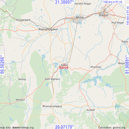
Balod GPS coordinates[2]
20° 43' 50.916" North, 81° 12' 20.808" East
| Map corner | latitude | longitude |
|---|---|---|
| Upper-left | 21.38697°, | 80.50266° |
| Center: | 20.73081°, | 81.20578° |
| Lower-right: | 20.07179°, | 81.90891° |
| Map W x H: | 146.2×146.2 km | = 90.8×90.8mi |
| max Lat: | 34.9274° ⇑62.9% North |
| Balod: | 20.73081° |
| min Lat: | ⇓37.1% South 8.09008° |
| min Long | Balod | max Long |
| 68.82655° | 81.20578° | 96.81° |
| W 73.6%⇐ | ⇒26.4% E |
Elevation
Elevation of Balod is 329 m = 1079 ft, and this is 33.4 m = 110 ft above average elevation for this country.
| Max E: |
3681 m = 12077 ft | 29.8% |
| Balod | 329 m 1079 ft | |
| Avg. | 295.6 m = 970 ft | |
Min E: |
1 m = 3 ft | 70.2% |
See also: India elevation on elevation.city.
Geographical zone
Balod is located in North Torrid zone (between Equator and Tropic of Cancer). Distance of this Northern Tropic circle is 300.9 km =187 mi to North.| Distance of | km | miles | from Balod |
|---|---|---|---|
| North Pole | 7702 | 4785.8 | to North |
| Arctic Circle | 5096.1 | 3166.6 | to North |
| Tropic Cancer | 300.9 | 187 | to North |
| Equator | 2305 | 1432.3 | to South |


Nearby cities:
15 places around Balod: (largest is in red/bold)
• Ambāgarh Chauki
48.1 km =29.9 mi,  276°
276°
• Bhatgaon
69.3 km =43.1 mi,  47°
47°
• Bhilai
58 km =36 mi,  23°
23°
• Bhānpurī
49.2 km =30.6 mi,  324°
324°
• Dhamtari
35.8 km =22.2 mi,  94°
94°
• Dongargaon
45.6 km =28.3 mi,  305°
305°
• Dongargarh
69.2 km =43 mi, 317°
• Durg
51.7 km =32.1 mi,  8°
8°
• Kumhāri
67.8 km =42.1 mi,  28°
28°
• Kurud
54.8 km =34.1 mi,  78°
78°
• Kānker
59.1 km =36.7 mi,  149°
149°
• Narharpur
53.3 km =33.1 mi,  126°
126°
• Pātan
47.8 km =29.7 mi, 45°
• Raipur
71.4 km =44.4 mi,  38°
38°
• Rāj-Nāndgaon
44.7 km =27.8 mi,  335°
335°
Sources, notices
• [Note1] Compared only with cities in India existing in our database
• [Src1] Map data: © OpenStreetMap contributors (CC-BY-SA)
• [Src2] Other city data from geonames.org with taken over terms of usage.
• [Src3] Geographical zone / Annual Mean Temperature by Robert A. Rohde @ Wikipedia
