Bhatgaon geodata
Bhatgaon (Chhattisgarh) is a populated place; located in India in Asia/Kolkata (GMT+5.5) time zone. With population of 8,044 people, there are 3122 cities with bigger population in this country. Compared to other cities in India, 61% of cities are located further ↑North; 75.6% of cities are located further ←West and 66% of cities have lower elevation than Bhatgaon. Note1


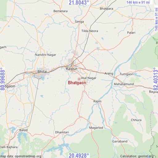
Bhatgaon GPS coordinates[2]
21° 9' 0" North, 81° 42' 0" East
| Map corner | latitude | longitude |
|---|---|---|
| Upper-left | 21.8043°, | 80.99688° |
| Center: | 21.15°, | 81.7° |
| Lower-right: | 20.4928°, | 82.40313° |
| Map W x H: | 145.8×145.8 km | = 90.6×90.6mi |
| max Lat: | 34.9274° ⇑61% North |
| Bhatgaon: | 21.15° |
| min Lat: | ⇓39% South 8.09008° |
| min Long | Bhatgaon | max Long |
| 68.82655° | 81.7° | 96.81° |
| W 75.6%⇐ | ⇒24.4% E |
Elevation
Elevation of Bhatgaon is 294 m = 965 ft, and this is 1.6 m = 5 ft below average elevation for this country.
| Max E: |
3681 m = 12077 ft | 34% |
| Avg. | 295.6 m = 970 ft | |
| Bhatgaon | 294 m = 965 ft | |
Min E: |
1 m = 3 ft | 66% |
See also: India elevation on elevation.city.
Geographical zone
Bhatgaon is located in North Torrid zone (between Equator and Tropic of Cancer). Distance of this Northern Tropic circle is 254.3 km =158 mi to North.| Distance of | km | miles | from Bhatgaon |
|---|---|---|---|
| North Pole | 7655.4 | 4756.8 | to North |
| Arctic Circle | 5049.5 | 3137.6 | to North |
| Tropic Cancer | 254.3 | 158 | to North |
| Equator | 2351.7 | 1461.3 | to South |


Nearby cities:
15 places around Bhatgaon: (largest is in red/bold)
• Arang
28.4 km =17.6 mi,  79°
79°
• Balod
69.3 km =43.1 mi,  227°
227°
• Bemetāra
65.2 km =40.5 mi,  344°
344°
• Bhilai
28.9 km =18 mi,  283°
283°
• Bhātāpāra
69.9 km =43.4 mi,  21°
21°
• Dhamtari
51.7 km =32.1 mi,  197°
197°
• Durg
44.2 km =27.5 mi, 275°
• Gariāband
68.7 km =42.7 mi,  146°
146°
• Khamharia
60.4 km =37.5 mi,  108°
108°
• Kumhāri
23 km =14.3 mi,  304°
304°
• Kurud
35.6 km =22.1 mi,  176°
176°
• Mahāsamund
41.2 km =25.6 mi,  96°
96°
• Pātan
21.6 km =13.4 mi, 233°
• Raipur
11.6 km =7.2 mi,  323°
323°
• Simga
53.2 km =33.1 mi,  0°
0°
Sources, notices
• [Note1] Compared only with cities in India existing in our database
• [Src1] Map data: © OpenStreetMap contributors (CC-BY-SA)
• [Src2] Other city data from geonames.org with taken over terms of usage.
• [Src3] Geographical zone / Annual Mean Temperature by Robert A. Rohde @ Wikipedia
