Raipur geodata
Raipur (Chhattisgarh) is a seat of a first-order administrative division; located in India in Asia/Kolkata (GMT+5.5) time zone. With population of 679,995 people, there are 66 cities with bigger population in this country. Compared to other cities in India, 60.5% of cities are located further ↑North; 75.2% of cities are located further ←West and 66.4% of cities have lower elevation than Raipur. Note1


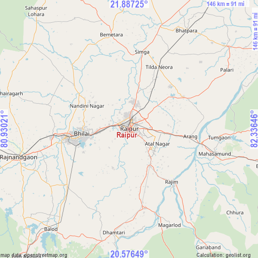
Raipur GPS coordinates[2]
21° 13' 59.988" North, 81° 37' 59.988" East
| Map corner | latitude | longitude |
|---|---|---|
| Upper-left | 21.88725°, | 80.93021° |
| Center: | 21.23333°, | 81.63333° |
| Lower-right: | 20.57649°, | 82.33646° |
| Map W x H: | 145.7×145.7 km | = 90.5×90.5mi |
| max Lat: | 34.9274° ⇑60.5% North |
| Raipur: | 21.23333° |
| min Lat: | ⇓39.5% South 8.09008° |
| min Long | Raipur | max Long |
| 68.82655° | 81.63333° | 96.81° |
| W 75.2%⇐ | ⇒24.8% E |
Elevation
Elevation of Raipur is 296 m = 971 ft, and this is 0.39999999999998 m = 1 ft above average elevation for this country.
| Max E: |
3681 m = 12077 ft | 33.6% |
| Raipur | 296 m 971 ft | |
| Avg. | 295.6 m = 970 ft | |
Min E: |
1 m = 3 ft | 66.4% |
See also: Raipur elevation on elevation.city.
Geographical zone
Raipur is located in North Torrid zone (between Equator and Tropic of Cancer). Distance of this Northern Tropic circle is 245 km =152.2 mi to North.| Distance of | km | miles | from Raipur |
|---|---|---|---|
| North Pole | 7646.1 | 4751.1 | to North |
| Arctic Circle | 5040.2 | 3131.8 | to North |
| Tropic Cancer | 245 | 152.2 | to North |
| Equator | 2360.9 | 1467 | to South |


Nearby cities:
15 places around Raipur: (largest is in red/bold)
• Arang
35 km =21.7 mi,  96°
96°
• Bemetāra
54.6 km =33.9 mi,  349°
349°
• Bhatgaon
11.6 km =7.2 mi,  143°
143°
• Bhilai
21.4 km =13.3 mi,  262°
262°
• Bhātāpāra
64.5 km =40.1 mi,  30°
30°
• Dhamtari
59.2 km =36.8 mi,  188°
188°
• Durg
37.3 km =23.2 mi, 262°
• Khairāgarh
70.8 km =44 mi,  286°
286°
• Khamharia
70.2 km =43.6 mi,  114°
114°
• Kumhāri
12.6 km =7.8 mi, 287°
• Kurud
45.7 km =28.4 mi,  168°
168°
• Mahāsamund
49.9 km =31 mi, 106°
• Pātan
24.5 km =15.2 mi,  205°
205°
• Rāj-Nāndgaon
64.5 km =40.1 mi, 256°
• Simga
44.5 km =27.7 mi,  9°
9°
Sources, notices
• [Note1] Compared only with cities in India existing in our database
• [Src1] Map data: © OpenStreetMap contributors (CC-BY-SA)
• [Src2] Other city data from geonames.org with taken over terms of usage.
• [Src3] Geographical zone / Annual Mean Temperature by Robert A. Rohde @ Wikipedia
