Rāj-Nāndgaon geodata
Rāj-Nāndgaon (Chhattisgarh) is a populated place; located in India in Asia/Kolkata (GMT+5.5) time zone. With population of 150,755 people, there are 292 cities with bigger population in this country. Compared to other cities in India, 61.2% of cities are located further ↑North; 73% of cities are located further ←West and 67.6% of cities have lower elevation than Rāj-Nāndgaon. Note1


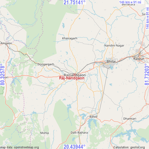
Rāj-Nāndgaon GPS coordinates[2]
21° 5' 48.732" North, 81° 1' 44.04" East
| Map corner | latitude | longitude |
|---|---|---|
| Upper-left | 21.75141°, | 80.32578° |
| Center: | 21.09687°, | 81.0289° |
| Lower-right: | 20.43944°, | 81.73203° |
| Map W x H: | 145.9×145.9 km | = 90.7×90.7mi |
| max Lat: | 34.9274° ⇑61.2% North |
| Rāj-Nāndgaon: | 21.09687° |
| min Lat: | ⇓38.8% South 8.09008° |
| min Long | Rāj-Nāndgaon | max Long |
| 68.82655° | 81.0289° | 96.81° |
| W 73%⇐ | ⇒27% E |
Elevation
Elevation of Rāj-Nāndgaon is 306 m = 1004 ft, and this is 10.4 m = 34 ft above average elevation for this country.
| Max E: |
3681 m = 12077 ft | 32.4% |
| Rāj-Nāndgaon | 306 m 1004 ft | |
| Avg. | 295.6 m = 970 ft | |
Min E: |
1 m = 3 ft | 67.6% |
See also: Rāj-Nāndgaon elevation on elevation.city.
Geographical zone
Rāj-Nāndgaon is located in North Torrid zone (between Equator and Tropic of Cancer). Distance of this Northern Tropic circle is 260.2 km =161.7 mi to North.| Distance of | km | miles | from Rāj-Nāndgaon |
|---|---|---|---|
| North Pole | 7661.3 | 4760.5 | to North |
| Arctic Circle | 5055.4 | 3141.3 | to North |
| Tropic Cancer | 260.2 | 161.7 | to North |
| Equator | 2345.8 | 1457.6 | to South |


Nearby cities:
15 places around Rāj-Nāndgaon: (largest is in red/bold)
• Ambāgarh Chauki
46.2 km =28.7 mi,  219°
219°
• Balod
44.7 km =27.8 mi,  155°
155°
• Bhatgaon
69.9 km =43.4 mi,  85°
85°
• Bhilai
43.3 km =26.9 mi,  73°
73°
• Bhānpurī
10 km =6.2 mi,  266°
266°
• Chhuīkhadān
47.5 km =29.5 mi,  356°
356°
• Dhamtari
69.2 km =43 mi,  128°
128°
• Dongargaon
23.1 km =14.4 mi,  233°
233°
• Dongargarh
30.2 km =18.8 mi,  289°
289°
• Durg
27.7 km =17.2 mi, 67°
• Gandai
63.8 km =39.6 mi,  6°
6°
• Khairāgarh
36.1 km =22.4 mi,  351°
351°
• Kumhāri
54 km =33.6 mi, 69°
• Pātan
52.8 km =32.8 mi,  97°
97°
• Raipur
64.5 km =40.1 mi,  76°
76°
Sources, notices
• [Note1] Compared only with cities in India existing in our database
• [Src1] Map data: © OpenStreetMap contributors (CC-BY-SA)
• [Src2] Other city data from geonames.org with taken over terms of usage.
• [Src3] Geographical zone / Annual Mean Temperature by Robert A. Rohde @ Wikipedia
