Durg geodata
Durg (Chhattisgarh) is a populated place; located in India in Asia/Kolkata (GMT+5.5) time zone. With population of 255,283 people, there are 167 cities with bigger population in this country. Compared to other cities in India, 60.7% of cities are located further ↑North; 73.9% of cities are located further ←West and 67.2% of cities have lower elevation than Durg. Note1


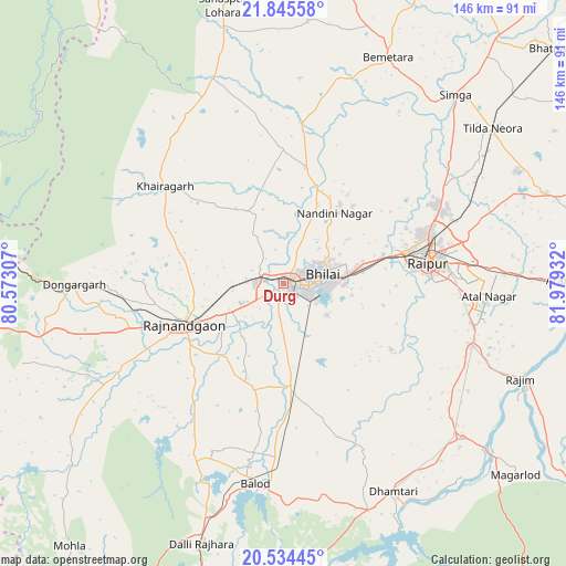
Durg GPS coordinates[2]
21° 11' 29.292" North, 81° 16' 34.284" East
| Map corner | latitude | longitude |
|---|---|---|
| Upper-left | 21.84558°, | 80.57307° |
| Center: | 21.19147°, | 81.27619° |
| Lower-right: | 20.53445°, | 81.97932° |
| Map W x H: | 145.8×145.8 km | = 90.6×90.6mi |
| max Lat: | 34.9274° ⇑60.7% North |
| Durg: | 21.19147° |
| min Lat: | ⇓39.3% South 8.09008° |
| min Long | Durg | max Long |
| 68.82655° | 81.27619° | 96.81° |
| W 73.9%⇐ | ⇒26.1% E |
Elevation
Elevation of Durg is 303 m = 994 ft, and this is 7.4 m = 24 ft above average elevation for this country.
| Max E: |
3681 m = 12077 ft | 32.8% |
| Durg | 303 m 994 ft | |
| Avg. | 295.6 m = 970 ft | |
Min E: |
1 m = 3 ft | 67.2% |
See also: Durg elevation on elevation.city.
Geographical zone
Durg is located in North Torrid zone (between Equator and Tropic of Cancer). Distance of this Northern Tropic circle is 249.6 km =155.1 mi to North.| Distance of | km | miles | from Durg |
|---|---|---|---|
| North Pole | 7650.8 | 4754 | to North |
| Arctic Circle | 5044.9 | 3134.8 | to North |
| Tropic Cancer | 249.6 | 155.1 | to North |
| Equator | 2356.3 | 1464.1 | to South |


Nearby cities:
15 places around Durg: (largest is in red/bold)
• Balod
51.7 km =32.1 mi,  188°
188°
• Bhatgaon
44.2 km =27.5 mi,  95°
95°
• Bhilai
15.9 km =9.9 mi,  82°
82°
• Bhānpurī
37.4 km =23.2 mi,  252°
252°
• Chhuīkhadān
46.8 km =29.1 mi,  321°
321°
• Dhamtari
60.8 km =37.8 mi,  152°
152°
• Dongargaon
50.4 km =31.3 mi,  241°
241°
• Dongargarh
54.1 km =33.6 mi,  269°
269°
• Gandai
55.9 km =34.7 mi,  340°
340°
• Khairāgarh
39.8 km =24.7 mi,  309°
309°
• Kumhāri
26.3 km =16.3 mi,  71°
71°
• Kurud
61.2 km =38 mi,  130°
130°
• Pātan
31.9 km =19.8 mi,  123°
123°
• Raipur
37.3 km =23.2 mi, 82°
• Rāj-Nāndgaon
27.7 km =17.2 mi, 247°
Sources, notices
• [Note1] Compared only with cities in India existing in our database
• [Src1] Map data: © OpenStreetMap contributors (CC-BY-SA)
• [Src2] Other city data from geonames.org with taken over terms of usage.
• [Src3] Geographical zone / Annual Mean Temperature by Robert A. Rohde @ Wikipedia
