Bagulā geodata
Bagulā (West Bengal) is a populated place; located in India in Asia/Kolkata (GMT+5.5) time zone. With population of 20,999 people, there are 1970 cities with bigger population in this country. Compared to other cities in India, 53.9% of cities are located further ↓South; 94.7% of cities are located further ←West and 89.9% of cities have higher elevation than Bagulā. Note1


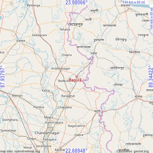
Bagulā GPS coordinates[2]
23° 20' 11.904" North, 88° 38' 27.924" East
| Map corner | latitude | longitude |
|---|---|---|
| Upper-left | 23.98066°, | 87.93797° |
| Center: | 23.33664°, | 88.64109° |
| Lower-right: | 22.68948°, | 89.34422° |
| Map W x H: | 143.6×143.6 km | = 89.2×89.2mi |
| max Lat: | 34.9274° ⇑46.1% North |
| Bagulā: | 23.33664° |
| min Lat: | ⇓53.9% South 8.09008° |
| min Long | Bagulā | max Long |
| 68.82655° | 88.64109° | 96.81° |
| W 94.7%⇐ | ⇒5.3% E |
Elevation
Elevation of Bagulā is 18 m = 59 ft, and this is 277.6 m = 911 ft below average elevation for this country.
| Max E: |
3681 m = 12077 ft | 89.9% |
| Avg. | 295.6 m = 970 ft | |
| Bagulā | 18 m = 59 ft | |
Min E: |
1 m = 3 ft | 10.1% |
See also: India elevation on elevation.city.
Geographical zone
Bagulā is located in North Torrid zone (between Equator and Tropic of Cancer). Distance of this Northern Tropic circle is 11.1 km =6.9 mi to North.| Distance of | km | miles | from Bagulā |
|---|---|---|---|
| North Pole | 7412.3 | 4605.8 | to North |
| Arctic Circle | 4806.4 | 2986.6 | to North |
| Tropic Cancer | 11.1 | 6.9 | to North |
| Equator | 2594.8 | 1612.3 | to South |


Nearby cities:
15 places around Bagulā: (largest is in red/bold)
• Aistala
18.5 km =11.5 mi,  199°
199°
• Bangaon
37.7 km =23.4 mi,  149°
149°
• Haringhāta
41.9 km =26 mi,  189°
189°
• Kalyani
42.5 km =26.4 mi, 202°
• Krishnanagar
17.2 km =10.7 mi,  296°
296°
• Kālna
31.3 km =19.4 mi,  245°
245°
• Kānchrāpāra
47.2 km =29.3 mi,  207°
207°
• Madanpur
39.8 km =24.7 mi, 202°
• Muragācha
33.6 km =20.9 mi,  311°
311°
• Nagarukhra
44 km =27.3 mi,  180°
180°
• Navadwīp
28.9 km =18 mi,  285°
285°
• Pandua
46.5 km =28.9 mi,  231°
231°
• Pātuli
45.3 km =28.1 mi, 302°
• Rānāghāt
19.4 km =12.1 mi, 203°
• Shāntipur
23.5 km =14.6 mi,  244°
244°
Sources, notices
• [Note1] Compared only with cities in India existing in our database
• [Src1] Map data: © OpenStreetMap contributors (CC-BY-SA)
• [Src2] Other city data from geonames.org with taken over terms of usage.
• [Src3] Geographical zone / Annual Mean Temperature by Robert A. Rohde @ Wikipedia
