Bangaon geodata
Bangaon (West Bengal) is a populated place; located in India in Asia/Kolkata (GMT+5.5) time zone. With population of 111,693 people, there are 398 cities with bigger population in this country. Compared to other cities in India, 52% of cities are located further ↓South; 95.1% of cities are located further ←West and 95.4% of cities have higher elevation than Bangaon. Note1


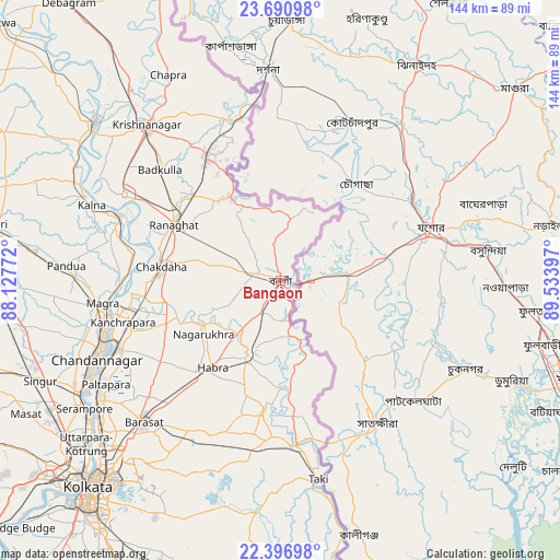
Bangaon GPS coordinates[2]
23° 2' 43.908" North, 88° 49' 51.024" East
| Map corner | latitude | longitude |
|---|---|---|
| Upper-left | 23.69098°, | 88.12772° |
| Center: | 23.04553°, | 88.83084° |
| Lower-right: | 22.39698°, | 89.53397° |
| Map W x H: | 143.9×143.9 km | = 89.4×89.4mi |
| max Lat: | 34.9274° ⇑48% North |
| Bangaon: | 23.04553° |
| min Lat: | ⇓52% South 8.09008° |
| min Long | Bangaon | max Long |
| 68.82655° | 88.83084° | 96.81° |
| W 95.1%⇐ | ⇒4.9% E |
Elevation
Elevation of Bangaon is 11 m = 36 ft, and this is 284.6 m = 934 ft below average elevation for this country.
| Max E: |
3681 m = 12077 ft | 95.4% |
| Avg. | 295.6 m = 970 ft | |
| Bangaon | 11 m = 36 ft | |
Min E: |
1 m = 3 ft | 4.6% |
See also: Bangaon elevation on elevation.city.
Geographical zone
Bangaon is located in North Torrid zone (between Equator and Tropic of Cancer). Distance of this Northern Tropic circle is 43.5 km =27 mi to North.| Distance of | km | miles | from Bangaon |
|---|---|---|---|
| North Pole | 7444.6 | 4625.9 | to North |
| Arctic Circle | 4838.8 | 3006.7 | to North |
| Tropic Cancer | 43.5 | 27 | to North |
| Equator | 2562.4 | 1592.2 | to South |


Nearby cities:
15 places around Bangaon: (largest is in red/bold)
• Aistala
29.7 km =18.5 mi,  300°
300°
• Ashoknagar Kalyangarh
28.3 km =17.6 mi,  224°
224°
• Badūria
33.8 km =21 mi,  187°
187°
• Bagulā
37.7 km =23.4 mi,  329°
329°
• Gobārdānga
20.3 km =12.6 mi,  202°
202°
• Gurdaha
35.3 km =21.9 mi, 191°
• Haringhāta
27.7 km =17.2 mi,  251°
251°
• Hābra
28.8 km =17.9 mi, 218°
• Hālīsahar
44 km =27.3 mi, 253°
• Kalyani
36.2 km =22.5 mi,  258°
258°
• Kānchrāpāra
42.3 km =26.3 mi, 256°
• Madanpur
35 km =21.7 mi, 262°
• Nagarukhra
23 km =14.3 mi,  239°
239°
• Rāmchandrapur
40 km =24.9 mi, 245°
• Rānāghāt
30.7 km =19.1 mi, 298°
Sources, notices
• [Note1] Compared only with cities in India existing in our database
• [Src1] Map data: © OpenStreetMap contributors (CC-BY-SA)
• [Src2] Other city data from geonames.org with taken over terms of usage.
• [Src3] Geographical zone / Annual Mean Temperature by Robert A. Rohde @ Wikipedia
