Alāwalpur geodata
Alāwalpur (Punjab) is a populated place; located in India in Asia/Kolkata (GMT+5.5) time zone. With population of 7,410 people, there are 3178 cities with bigger population in this country. Compared to other cities in India, 96.7% of cities are located further ↓South; 76.9% of cities are located further →East and 59.6% of cities have lower elevation than Alāwalpur. Note1


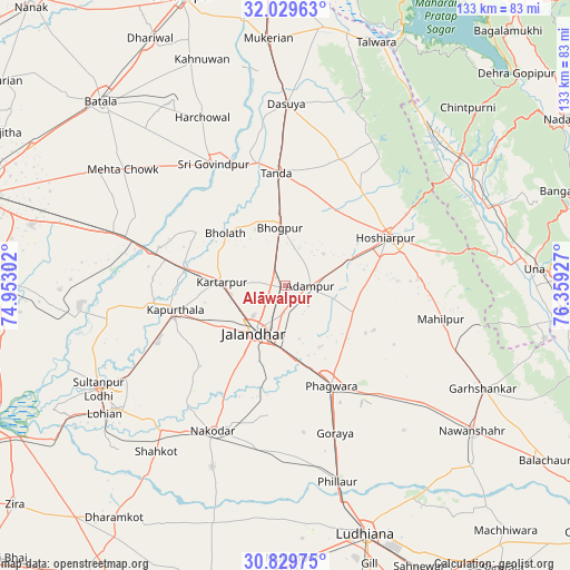
Alāwalpur GPS coordinates[2]
31° 25' 53.796" North, 75° 39' 22.104" East
| Map corner | latitude | longitude |
|---|---|---|
| Upper-left | 32.02963°, | 74.95302° |
| Center: | 31.43161°, | 75.65614° |
| Lower-right: | 30.82975°, | 76.35927° |
| Map W x H: | 133.4×133.4 km | = 82.9×82.9mi |
| max Lat: | 34.9274° ⇑3.3% North |
| Alāwalpur: | 31.43161° |
| min Lat: | ⇓96.7% South 8.09008° |
| min Long | Alāwalpur | max Long |
| 68.82655° | 75.65614° | 96.81° |
| W 23.1%⇐ | ⇒76.9% E |
Elevation
Elevation of Alāwalpur is 248 m = 814 ft, and this is 47.6 m = 156 ft below average elevation for this country.
| Max E: |
3681 m = 12077 ft | 40.4% |
| Avg. | 295.6 m = 970 ft | |
| Alāwalpur | 248 m = 814 ft | |
Min E: |
1 m = 3 ft | 59.6% |
See also: India elevation on elevation.city.
Geographical zone
Alāwalpur is located in North temperate zone (between Tropic of Cancer and the Arctic Circle). Distance of this Northern Tropic circle is 888.9 km =552.3 mi to South.| Distance of | km | miles | from Alāwalpur |
|---|---|---|---|
| North Pole | 6512.2 | 4046.5 | to North |
| Arctic Circle | 3906.3 | 2427.3 | to North |
| Tropic Cancer | 888.9 | 552.3 | to South |
| Equator | 3494.9 | 2171.6 | to South |


Nearby cities:
15 places around Alāwalpur: (largest is in red/bold)
• Adampur
5.6 km =3.5 mi,  89°
89°
• Begowāl
23.7 km =14.7 mi,  327°
327°
• Bhogpur
13.7 km =8.5 mi,  354°
354°
• Bhulath Gharbi
18.7 km =11.6 mi,  311°
311°
• Dhilwan
30.8 km =19.1 mi,  287°
287°
• Garhdiwāla
35.7 km =22.2 mi,  15°
15°
• Hariāna
28.5 km =17.7 mi,  37°
37°
• Hoshiārpur
27 km =16.8 mi,  64°
64°
• Jalandhar
13.9 km =8.6 mi,  211°
211°
• Jandiāla
30.5 km =19 mi,  186°
186°
• Kapūrthala
26.7 km =16.6 mi,  257°
257°
• Kartārpur
15 km =9.3 mi,  274°
274°
• Nūrmahal
37.7 km =23.4 mi, 189°
• Phagwāra
25.6 km =15.9 mi,  154°
154°
• Shām Churāsi
11.7 km =7.3 mi,  49°
49°
Sources, notices
• [Note1] Compared only with cities in India existing in our database
• [Src1] Map data: © OpenStreetMap contributors (CC-BY-SA)
• [Src2] Other city data from geonames.org with taken over terms of usage.
• [Src3] Geographical zone / Annual Mean Temperature by Robert A. Rohde @ Wikipedia
