Bhulath Gharbi geodata
Bhulath Gharbi (Punjab) is a populated place; located in India in Asia/Kolkata (GMT+5.5) time zone. With population of 10,669 people, there are 2873 cities with bigger population in this country. Compared to other cities in India, 97% of cities are located further ↓South; 78.5% of cities are located further →East and 57.1% of cities have lower elevation than Bhulath Gharbi. Note1


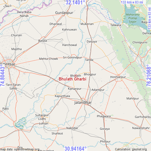
Bhulath Gharbi GPS coordinates[2]
31° 32' 34.044" North, 75° 30' 27.18" East
| Map corner | latitude | longitude |
|---|---|---|
| Upper-left | 32.1401°, | 74.80443° |
| Center: | 31.54279°, | 75.50755° |
| Lower-right: | 30.94164°, | 76.21068° |
| Map W x H: | 133.3×133.3 km | = 82.8×82.8mi |
| max Lat: | 34.9274° ⇑3% North |
| Bhulath Gharbi: | 31.54279° |
| min Lat: | ⇓97% South 8.09008° |
| min Long | Bhulath Gharbi | max Long |
| 68.82655° | 75.50755° | 96.81° |
| W 21.5%⇐ | ⇒78.5% E |
Elevation
Elevation of Bhulath Gharbi is 235 m = 771 ft, and this is 60.6 m = 199 ft below average elevation for this country.
| Max E: |
3681 m = 12077 ft | 42.9% |
| Avg. | 295.6 m = 970 ft | |
| Bhulath Gharbi | 235 m = 771 ft | |
Min E: |
1 m = 3 ft | 57.1% |
See also: India elevation on elevation.city.
Geographical zone
Bhulath Gharbi is located in North temperate zone (between Tropic of Cancer and the Arctic Circle). Distance of this Northern Tropic circle is 901.3 km =560 mi to South.| Distance of | km | miles | from Bhulath Gharbi |
|---|---|---|---|
| North Pole | 6499.8 | 4038.8 | to North |
| Arctic Circle | 3893.9 | 2419.6 | to North |
| Tropic Cancer | 901.3 | 560 | to South |
| Equator | 3507.2 | 2179.3 | to South |


Nearby cities:
15 places around Bhulath Gharbi: (largest is in red/bold)
• Adampur
23.2 km =14.4 mi,  122°
122°
• Alāwalpur
18.7 km =11.6 mi,  131°
131°
• Batāla
41.3 km =25.7 mi,  315°
315°
• Begowāl
7.8 km =4.8 mi,  9°
9°
• Bhogpur
12.9 km =8 mi,  84°
84°
• Dasūya
33.4 km =20.8 mi,  24°
24°
• Dhilwan
15.7 km =9.8 mi,  258°
258°
• Garhdiwāla
32.2 km =20 mi,  46°
46°
• Hariāna
33 km =20.5 mi,  71°
71°
• Hoshiārpur
38.4 km =23.9 mi,  90°
90°
• Jalandhar
25.1 km =15.6 mi,  164°
164°
• Kapūrthala
21.7 km =13.5 mi,  213°
213°
• Kartārpur
11.2 km =7 mi,  184°
184°
• Qādiān
33.4 km =20.8 mi,  338°
338°
• Shām Churāsi
23.4 km =14.5 mi,  101°
101°
Sources, notices
• [Note1] Compared only with cities in India existing in our database
• [Src1] Map data: © OpenStreetMap contributors (CC-BY-SA)
• [Src2] Other city data from geonames.org with taken over terms of usage.
• [Src3] Geographical zone / Annual Mean Temperature by Robert A. Rohde @ Wikipedia
