Hoshiārpur geodata
Hoshiārpur (Punjab) is a seat of a second-order administrative division; located in India in Asia/Kolkata (GMT+5.5) time zone. With population of 158,142 people, there are 277 cities with bigger population in this country. Compared to other cities in India, 97% of cities are located further ↓South; 74.5% of cities are located further →East and 68.4% of cities have lower elevation than Hoshiārpur. Note1


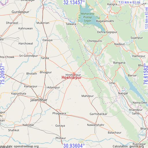
Hoshiārpur GPS coordinates[2]
31° 32' 14.028" North, 75° 54' 45.684" East
| Map corner | latitude | longitude |
|---|---|---|
| Upper-left | 32.13457°, | 75.20957° |
| Center: | 31.53723°, | 75.91269° |
| Lower-right: | 30.93604°, | 76.61582° |
| Map W x H: | 133.3×133.3 km | = 82.8×82.8mi |
| max Lat: | 34.9274° ⇑3% North |
| Hoshiārpur: | 31.53723° |
| min Lat: | ⇓97% South 8.09008° |
| min Long | Hoshiārpur | max Long |
| 68.82655° | 75.91269° | 96.81° |
| W 25.5%⇐ | ⇒74.5% E |
Elevation
Elevation of Hoshiārpur is 311 m = 1020 ft, and this is 15.4 m = 51 ft above average elevation for this country.
| Max E: |
3681 m = 12077 ft | 31.6% |
| Hoshiārpur | 311 m 1020 ft | |
| Avg. | 295.6 m = 970 ft | |
Min E: |
1 m = 3 ft | 68.4% |
See also: Hoshiārpur elevation on elevation.city.
Geographical zone
Hoshiārpur is located in North temperate zone (between Tropic of Cancer and the Arctic Circle). Distance of this Northern Tropic circle is 900.7 km =559.7 mi to South.| Distance of | km | miles | from Hoshiārpur |
|---|---|---|---|
| North Pole | 6500.5 | 4039.2 | to North |
| Arctic Circle | 3894.6 | 2420 | to North |
| Tropic Cancer | 900.7 | 559.7 | to South |
| Equator | 3506.6 | 2178.9 | to South |


Nearby cities:
15 places around Hoshiārpur: (largest is in red/bold)
• Adampur
22.1 km =13.7 mi,  238°
238°
• Alāwalpur
27 km =16.8 mi, 244°
• Banga
39.5 km =24.5 mi,  168°
168°
• Begowāl
38 km =23.6 mi,  282°
282°
• Bhogpur
25.7 km =16 mi,  274°
274°
• Bhulath Gharbi
38.4 km =23.9 mi, 270°
• Dasūya
39.6 km =24.6 mi,  321°
321°
• Daulatpur
28.9 km =18 mi,  14°
14°
• Gagret
19.5 km =12.1 mi,  46°
46°
• Garhdiwāla
27.1 km =16.8 mi,  326°
326°
• Hariāna
12.9 km =8 mi, 327°
• Jalandhar
39.4 km =24.5 mi,  233°
233°
• Phagwāra
37.2 km =23.1 mi,  200°
200°
• Shām Churāsi
16 km =9.9 mi,  255°
255°
• Una
34.7 km =21.6 mi,  103°
103°
Sources, notices
• [Note1] Compared only with cities in India existing in our database
• [Src1] Map data: © OpenStreetMap contributors (CC-BY-SA)
• [Src2] Other city data from geonames.org with taken over terms of usage.
• [Src3] Geographical zone / Annual Mean Temperature by Robert A. Rohde @ Wikipedia
