Garhdiwāla geodata
Garhdiwāla (Punjab) is a populated place; located in India in Asia/Kolkata (GMT+5.5) time zone. With population of 6,693 people, there are 3233 cities with bigger population in this country. Compared to other cities in India, 97.4% of cities are located further ↓South; 76.2% of cities are located further →East and 65.6% of cities have lower elevation than Garhdiwāla. Note1


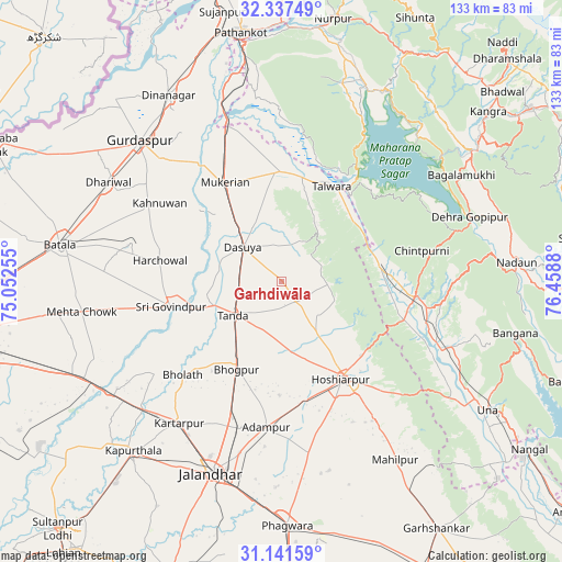
Garhdiwāla GPS coordinates[2]
31° 44' 29.292" North, 75° 45' 20.412" East
| Map corner | latitude | longitude |
|---|---|---|
| Upper-left | 32.33749°, | 75.05255° |
| Center: | 31.74147°, | 75.75567° |
| Lower-right: | 31.14159°, | 76.4588° |
| Map W x H: | 133×133 km | = 82.6×82.6mi |
| max Lat: | 34.9274° ⇑2.6% North |
| Garhdiwāla: | 31.74147° |
| min Lat: | ⇓97.4% South 8.09008° |
| min Long | Garhdiwāla | max Long |
| 68.82655° | 75.75567° | 96.81° |
| W 23.8%⇐ | ⇒76.2% E |
Elevation
Elevation of Garhdiwāla is 290 m = 951 ft, and this is 5.6 m = 18 ft below average elevation for this country.
| Max E: |
3681 m = 12077 ft | 34.4% |
| Avg. | 295.6 m = 970 ft | |
| Garhdiwāla | 290 m = 951 ft | |
Min E: |
1 m = 3 ft | 65.6% |
See also: India elevation on elevation.city.
Geographical zone
Garhdiwāla is located in North temperate zone (between Tropic of Cancer and the Arctic Circle). Distance of this Northern Tropic circle is 923.4 km =573.8 mi to South.| Distance of | km | miles | from Garhdiwāla |
|---|---|---|---|
| North Pole | 6477.7 | 4025.1 | to North |
| Arctic Circle | 3871.9 | 2405.9 | to North |
| Tropic Cancer | 923.4 | 573.8 | to South |
| Equator | 3529.3 | 2193 | to South |


Nearby cities:
15 places around Garhdiwāla: (largest is in red/bold)
• Adampur
34.6 km =21.5 mi,  186°
186°
• Alāwalpur
35.7 km =22.2 mi,  195°
195°
• Begowāl
26.5 km =16.5 mi,  236°
236°
• Bhogpur
23.4 km =14.5 mi,  207°
207°
• Bhulath Gharbi
32.2 km =20 mi,  226°
226°
• Dasūya
12.8 km =8 mi,  310°
310°
• Daulatpur
22.9 km =14.2 mi,  76°
76°
• Gagret
30.4 km =18.9 mi,  107°
107°
• Hariāna
14.2 km =8.8 mi,  146°
146°
• Hoshiārpur
27.1 km =16.8 mi, 146°
• Hājipur
26.2 km =16.3 mi,  359°
359°
• Mukeriān
27 km =16.8 mi,  331°
331°
• Qādiān
36.9 km =22.9 mi,  284°
284°
• Shām Churāsi
26.8 km =16.7 mi,  181°
181°
• Talwāra
25.1 km =15.6 mi,  29°
29°
Sources, notices
• [Note1] Compared only with cities in India existing in our database
• [Src1] Map data: © OpenStreetMap contributors (CC-BY-SA)
• [Src2] Other city data from geonames.org with taken over terms of usage.
• [Src3] Geographical zone / Annual Mean Temperature by Robert A. Rohde @ Wikipedia
