Hariāna geodata
Hariāna (Punjab) is a populated place; located in India in Asia/Kolkata (GMT+5.5) time zone. With population of 8,332 people, there are 3095 cities with bigger population in this country. Compared to other cities in India, 97.2% of cities are located further ↓South; 75.3% of cities are located further →East and 68.3% of cities have lower elevation than Hariāna. Note1


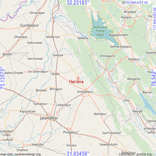
Hariāna GPS coordinates[2]
31° 38' 6.432" North, 75° 50' 19.932" East
| Map corner | latitude | longitude |
|---|---|---|
| Upper-left | 32.23183°, | 75.13575° |
| Center: | 31.63512°, | 75.83887° |
| Lower-right: | 31.03456°, | 76.542° |
| Map W x H: | 133.1×133.1 km | = 82.7×82.7mi |
| max Lat: | 34.9274° ⇑2.8% North |
| Hariāna: | 31.63512° |
| min Lat: | ⇓97.2% South 8.09008° |
| min Long | Hariāna | max Long |
| 68.82655° | 75.83887° | 96.81° |
| W 24.7%⇐ | ⇒75.3% E |
Elevation
Elevation of Hariāna is 310 m = 1017 ft, and this is 14.4 m = 47 ft above average elevation for this country.
| Max E: |
3681 m = 12077 ft | 31.7% |
| Hariāna | 310 m 1017 ft | |
| Avg. | 295.6 m = 970 ft | |
Min E: |
1 m = 3 ft | 68.3% |
See also: India elevation on elevation.city.
Geographical zone
Hariāna is located in North temperate zone (between Tropic of Cancer and the Arctic Circle). Distance of this Northern Tropic circle is 911.6 km =566.4 mi to South.| Distance of | km | miles | from Hariāna |
|---|---|---|---|
| North Pole | 6489.6 | 4032.4 | to North |
| Arctic Circle | 3883.7 | 2413.2 | to North |
| Tropic Cancer | 911.6 | 566.4 | to South |
| Equator | 3517.5 | 2185.7 | to South |


Nearby cities:
15 places around Hariāna: (largest is in red/bold)
• Adampur
25.4 km =15.8 mi,  207°
207°
• Alāwalpur
28.5 km =17.7 mi,  217°
217°
• Begowāl
30.2 km =18.8 mi,  265°
265°
• Bhogpur
20.6 km =12.8 mi,  244°
244°
• Bhulath Gharbi
33 km =20.5 mi,  251°
251°
• Dasūya
26.8 km =16.7 mi,  318°
318°
• Daulatpur
22.4 km =13.9 mi,  40°
40°
• Gagret
21.2 km =13.2 mi,  82°
82°
• Garhdiwāla
14.2 km =8.8 mi,  326°
326°
• Hoshiārpur
12.9 km =8 mi,  147°
147°
• Hājipur
38.9 km =24.2 mi,  348°
348°
• Kartārpur
38.7 km =24 mi, 236°
• Mukeriān
41.2 km =25.6 mi, 329°
• Shām Churāsi
17.2 km =10.7 mi, 209°
• Talwāra
33.9 km =21.1 mi,  7°
7°
Sources, notices
• [Note1] Compared only with cities in India existing in our database
• [Src1] Map data: © OpenStreetMap contributors (CC-BY-SA)
• [Src2] Other city data from geonames.org with taken over terms of usage.
• [Src3] Geographical zone / Annual Mean Temperature by Robert A. Rohde @ Wikipedia
