Shām Churāsi geodata
Shām Churāsi (Punjab) is a populated place; located in India in Asia/Kolkata (GMT+5.5) time zone. With population of 4,403 people, there are 3364 cities with bigger population in this country. Compared to other cities in India, 96.9% of cities are located further ↓South; 76.3% of cities are located further →East and 61.5% of cities have lower elevation than Shām Churāsi. Note1


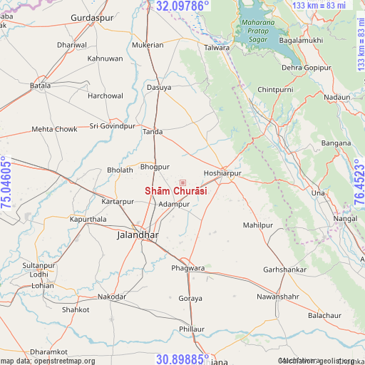
Shām Churāsi GPS coordinates[2]
31° 30' 1.008" North, 75° 44' 57.012" East
| Map corner | latitude | longitude |
|---|---|---|
| Upper-left | 32.09786°, | 75.04605° |
| Center: | 31.50028°, | 75.74917° |
| Lower-right: | 30.89885°, | 76.4523° |
| Map W x H: | 133.3×133.3 km | = 82.8×82.8mi |
| max Lat: | 34.9274° ⇑3.1% North |
| Shām Churāsi: | 31.50028° |
| min Lat: | ⇓96.9% South 8.09008° |
| min Long | Shām Churāsi | max Long |
| 68.82655° | 75.74917° | 96.81° |
| W 23.7%⇐ | ⇒76.3% E |
Elevation
Elevation of Shām Churāsi is 262 m = 860 ft, and this is 33.6 m = 110 ft below average elevation for this country.
| Max E: |
3681 m = 12077 ft | 38.5% |
| Avg. | 295.6 m = 970 ft | |
| Shām Churāsi | 262 m = 860 ft | |
Min E: |
1 m = 3 ft | 61.5% |
See also: India elevation on elevation.city.
Geographical zone
Shām Churāsi is located in North temperate zone (between Tropic of Cancer and the Arctic Circle). Distance of this Northern Tropic circle is 896.6 km =557.1 mi to South.| Distance of | km | miles | from Shām Churāsi |
|---|---|---|---|
| North Pole | 6504.6 | 4041.8 | to North |
| Arctic Circle | 3898.7 | 2422.5 | to North |
| Tropic Cancer | 896.6 | 557.1 | to South |
| Equator | 3502.5 | 2176.4 | to South |


Nearby cities:
15 places around Shām Churāsi: (largest is in red/bold)
• Adampur
8.2 km =5.1 mi,  203°
203°
• Alāwalpur
11.7 km =7.3 mi,  229°
229°
• Begowāl
24.9 km =15.5 mi,  299°
299°
• Bhogpur
11.7 km =7.3 mi, 300°
• Bhulath Gharbi
23.4 km =14.5 mi,  281°
281°
• Dasūya
36.3 km =22.6 mi,  345°
345°
• Dhilwan
38.3 km =23.8 mi,  272°
272°
• Gagret
34.4 km =21.4 mi,  59°
59°
• Garhdiwāla
26.8 km =16.7 mi,  1°
1°
• Hariāna
17.2 km =10.7 mi,  29°
29°
• Hoshiārpur
16 km =9.9 mi,  75°
75°
• Jalandhar
25.3 km =15.7 mi,  219°
219°
• Kapūrthala
37.4 km =23.2 mi,  249°
249°
• Kartārpur
24.6 km =15.3 mi, 254°
• Phagwāra
30.8 km =19.1 mi,  175°
175°
Sources, notices
• [Note1] Compared only with cities in India existing in our database
• [Src1] Map data: © OpenStreetMap contributors (CC-BY-SA)
• [Src2] Other city data from geonames.org with taken over terms of usage.
• [Src3] Geographical zone / Annual Mean Temperature by Robert A. Rohde @ Wikipedia
