Borūjen geodata
Borūjen (Chaharmahal and Bakhtiari) is a seat of a second-order administrative division; located in Iran in Asia/Tehran (GMT+3.5) time zone. With population of 52,654 people, there are 120 cities with bigger population in this country. Compared to other cities in Iran, 69.8% of cities are located further ↑North; 50.3% of cities are located further →East and 97.5% of cities have lower elevation than Borūjen. Note1


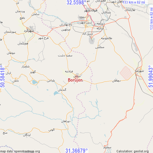
Borūjen GPS coordinates[2]
31° 57' 54.828" North, 51° 17' 14.28" East
| Map corner | latitude | longitude |
|---|---|---|
| Upper-left | 32.5598°, | 50.58418° |
| Center: | 31.96523°, | 51.2873° |
| Lower-right: | 31.36679°, | 51.99043° |
| Map W x H: | 132.7×132.7 km | = 82.5×82.5mi |
| max Lat: | 39.6482° ⇑69.8% North |
| Borūjen: | 31.96523° |
| min Lat: | ⇓30.2% South 25.2919° |
| min Long | Borūjen | max Long |
| 44.38416° | 51.2873° | 61.9965° |
| W 49.7%⇐ | ⇒50.3% E |
Elevation
Elevation of Borūjen is 2230 m = 7316 ft, and this is 1181 m = 3875 ft above average elevation for this country.
| Max E: |
2564 m = 8412 ft | 2.5% |
| Borūjen | 2230 m 7316 ft | |
| Avg. | 1049 m = 3442 ft | |
Min E: |
-24 m = -79 ft | 97.5% |
See also: Borūjen elevation on elevation.city.
Geographical zone
Borūjen is located in North temperate zone (between Tropic of Cancer and the Arctic Circle). Distance of this Northern Tropic circle is 948.3 km =589.2 mi to South.| Distance of | km | miles | from Borūjen |
|---|---|---|---|
| North Pole | 6452.9 | 4009.6 | to North |
| Arctic Circle | 3847 | 2390.4 | to North |
| Tropic Cancer | 948.3 | 589.2 | to South |
| Equator | 3554.2 | 2208.5 | to South |


Nearby cities:
15 places around Borūjen: (largest is in red/bold)
• Abrīsham
71 km =44.1 mi,  22°
22°
• Ardal
59.1 km =36.7 mi,  273°
273°
• Dehāqān
34.1 km =21.2 mi,  94°
94°
• Falāvarjān
68.9 km =42.8 mi, 17°
• Farrokh Shahr
44.7 km =27.8 mi,  319°
319°
• Kelīshād va Sūdarjān
69 km =42.9 mi, 19°
• Lordegān
66.5 km =41.3 mi,  220°
220°
• Mobārakeh
47.1 km =29.3 mi,  25°
25°
• Najafābād
74.8 km =46.5 mi,  5°
5°
• Qahderījān
69.8 km =43.4 mi, 13°
• Semīrom
66.5 km =41.3 mi,  156°
156°
• Shahr-e Kord
57 km =35.4 mi,  314°
314°
• Shahreẕā
54.9 km =34.1 mi,  84°
84°
• Shalamzār
45.3 km =28.1 mi,  281°
281°
• Zarrīn Shahr
47.9 km =29.8 mi, 10°
Sources, notices
• [Note1] Compared only with cities in Iran existing in our database
• [Src1] Map data: © OpenStreetMap contributors (CC-BY-SA)
• [Src2] Other city data from geonames.org with taken over terms of usage.
• [Src3] Geographical zone / Annual Mean Temperature by Robert A. Rohde @ Wikipedia
