Zambrone geodata
Zambrone (Calabria) is a seat of a third-order administrative division; located in Italy in Europe/Rome (GMT+2) time zone. With population of 558 people, there are 9366 cities with bigger population in this country. Compared to other cities in Italy, 93.4% of cities are located further ↑North; 92.8% of cities are located further ←West and 51.6% of cities have higher elevation than Zambrone. Note1


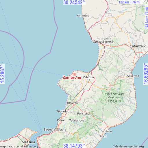
Zambrone GPS coordinates[2]
38° 41' 55.608" North, 15° 59' 23.352" East
| Map corner | latitude | longitude |
|---|---|---|
| Upper-left | 39.24542°, | 15.2867° |
| Center: | 38.69878°, | 15.98982° |
| Lower-right: | 38.14793°, | 16.69295° |
| Map W x H: | 122×122 km | = 75.8×75.8mi |
| max Lat: | 47.04031° ⇑93.4% North |
| Zambrone: | 38.69878° |
| min Lat: | ⇓6.6% South 35.50142° |
| min Long | Zambrone | max Long |
| 6.69888° | 15.98982° | 18.48682° |
| W 92.8%⇐ | ⇒7.2% E |
Elevation
Elevation of Zambrone is 224 m = 735 ft, and this is 82.7 m = 271 ft below average elevation for this country.
| Max E: |
2085 m = 6841 ft | 51.6% |
| Avg. | 306.7 m = 1006 ft | |
| Zambrone | 224 m = 735 ft | |
Min E: |
-4 m = -13 ft | 48.4% |
See also: Italy elevation on elevation.city.
Geographical zone
Zambrone is located in North temperate zone (between Tropic of Cancer and the Arctic Circle). Distance of this Northern Tropic circle is 1697 km =1054.5 mi to South.| Distance of | km | miles | from Zambrone |
|---|---|---|---|
| North Pole | 5704.2 | 3544.4 | to North |
| Arctic Circle | 3098.3 | 1925.2 | to North |
| Tropic Cancer | 1697 | 1054.5 | to South |
| Equator | 4302.9 | 2673.7 | to South |


Nearby cities:
15 places around Zambrone: (largest is in red/bold)
• Arzona-Pizzinni
9.6 km =6 mi,  148°
148°
• Briatico
4.2 km =2.6 mi,  50°
50°
• Caria
9.5 km =5.9 mi,  232°
232°
• Cessaniti
5.2 km =3.2 mi,  138°
138°
• Drapia
7.7 km =4.8 mi,  241°
241°
• Filandari
10 km =6.2 mi,  158°
158°
• Jonadi
9.8 km =6.1 mi, 141°
• Pannaconi
4.8 km =3 mi,  97°
97°
• Parghelia
6.3 km =3.9 mi,  252°
252°
• Pernocari-Presinaci
9.8 km =6.1 mi,  172°
172°
• San Costantino
1.3 km =0.8 mi,  58°
58°
• Tropea
8.7 km =5.4 mi, 251°
• Vibo Valentia
10 km =6.2 mi, 104°
• Zaccanopoli
6.5 km =4 mi, 235°
• Zungri
4.7 km =2.9 mi,  186°
186°
Sources, notices
• [Note1] Compared only with cities in Italy existing in our database
• [Src1] Map data: © OpenStreetMap contributors (CC-BY-SA)
• [Src2] Other city data from geonames.org with taken over terms of usage.
• [Src3] Geographical zone / Annual Mean Temperature by Robert A. Rohde @ Wikipedia
