Zungri geodata
Zungri (Calabria) is a seat of a third-order administrative division; located in Italy in Europe/Rome (GMT+2) time zone. With population of 1,741 people, there are 4591 cities with bigger population in this country. Compared to other cities in Italy, 93.6% of cities are located further ↑North; 92.7% of cities are located further ←West and 81.3% of cities have lower elevation than Zungri. Note1


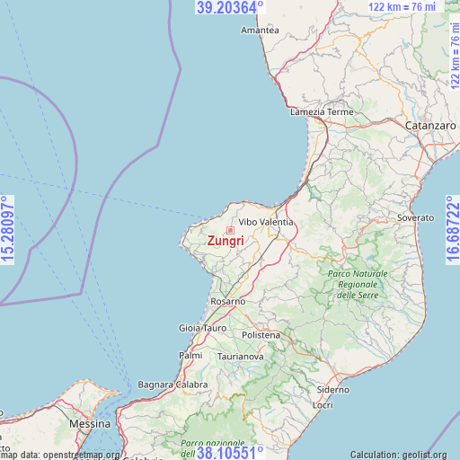
Zungri GPS coordinates[2]
38° 39' 24.048" North, 15° 59' 2.724" East
| Map corner | latitude | longitude |
|---|---|---|
| Upper-left | 39.20364°, | 15.28097° |
| Center: | 38.65668°, | 15.98409° |
| Lower-right: | 38.10551°, | 16.68722° |
| Map W x H: | 122.1×122.1 km | = 75.9×75.9mi |
| max Lat: | 47.04031° ⇑93.6% North |
| Zungri: | 38.65668° |
| min Lat: | ⇓6.4% South 35.50142° |
| min Long | Zungri | max Long |
| 6.69888° | 15.98409° | 18.48682° |
| W 92.7%⇐ | ⇒7.3% E |
Elevation
Elevation of Zungri is 543 m = 1781 ft, and this is 236.3 m = 775 ft above average elevation for this country.
| Max E: |
2085 m = 6841 ft | 18.7% |
| Zungri | 543 m 1781 ft | |
| Avg. | 306.7 m = 1006 ft | |
Min E: |
-4 m = -13 ft | 81.3% |
See also: Italy elevation on elevation.city.
Geographical zone
Zungri is located in North temperate zone (between Tropic of Cancer and the Arctic Circle). Distance of this Northern Tropic circle is 1692.3 km =1051.5 mi to South.| Distance of | km | miles | from Zungri |
|---|---|---|---|
| North Pole | 5708.8 | 3547.3 | to North |
| Arctic Circle | 3103 | 1928.1 | to North |
| Tropic Cancer | 1692.3 | 1051.5 | to South |
| Equator | 4298.2 | 2670.8 | to South |


Nearby cities:
15 places around Zungri: (largest is in red/bold)
• Arzona-Pizzinni
6.5 km =4 mi,  122°
122°
• Caria
7.1 km =4.4 mi,  261°
261°
• Cessaniti
4 km =2.5 mi,  78°
78°
• Drapia
6.4 km =4 mi,  279°
279°
• Filandari
6.2 km =3.9 mi,  138°
138°
• Jonadi
7.3 km =4.5 mi,  114°
114°
• Pannaconi
6.6 km =4.1 mi,  52°
52°
• Parghelia
6.2 km =3.9 mi,  297°
297°
• Pernocari-Presinaci
5.3 km =3.3 mi,  160°
160°
• Rombiolo
7 km =4.3 mi,  166°
166°
• San Costantino
5.6 km =3.5 mi,  16°
16°
• Spilinga
7.5 km =4.7 mi,  245°
245°
• Tropea
8 km =5 mi, 284°
• Zaccanopoli
4.9 km =3 mi, 281°
• Zambrone
4.7 km =2.9 mi,  6°
6°
Sources, notices
• [Note1] Compared only with cities in Italy existing in our database
• [Src1] Map data: © OpenStreetMap contributors (CC-BY-SA)
• [Src2] Other city data from geonames.org with taken over terms of usage.
• [Src3] Geographical zone / Annual Mean Temperature by Robert A. Rohde @ Wikipedia
