Parghelia geodata
Parghelia (Calabria) is a seat of a third-order administrative division; located in Italy in Europe/Rome (GMT+2) time zone. With population of 1,081 people, there are 6366 cities with bigger population in this country. Compared to other cities in Italy, 93.5% of cities are located further ↑North; 92.4% of cities are located further ←West and 73.6% of cities have higher elevation than Parghelia. Note1
Administrative division(s):
- Level 1: Calabria
- Level 2: Provincia di Vibo-Valentia
- Level 3: Parghelia


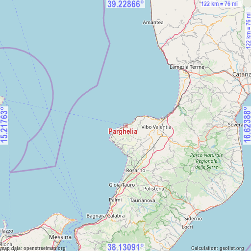
Parghelia GPS coordinates[2]
38° 40' 54.804" North, 15° 55' 14.7" East
| Map corner | latitude | longitude |
|---|---|---|
| Upper-left | 39.22866°, | 15.21763° |
| Center: | 38.68189°, | 15.92075° |
| Lower-right: | 38.13091°, | 16.62388° |
| Map W x H: | 122.1×122.1 km | = 75.9×75.9mi |
| max Lat: | 47.04031° ⇑93.5% North |
| Parghelia: | 38.68189° |
| min Lat: | ⇓6.5% South 35.50142° |
| min Long | Parghelia | max Long |
| 6.69888° | 15.92075° | 18.48682° |
| W 92.4%⇐ | ⇒7.6% E |
Elevation
Elevation of Parghelia is 80 m = 262 ft, and this is 226.7 m = 744 ft below average elevation for this country.
| Max E: |
2085 m = 6841 ft | 73.6% |
| Avg. | 306.7 m = 1006 ft | |
| Parghelia | 80 m = 262 ft | |
Min E: |
-4 m = -13 ft | 26.4% |
See also: Italy elevation on elevation.city.
Geographical zone
Parghelia is located in North temperate zone (between Tropic of Cancer and the Arctic Circle). Distance of this Northern Tropic circle is 1695.1 km =1053.3 mi to South.| Distance of | km | miles | from Parghelia |
|---|---|---|---|
| North Pole | 5706 | 3545.5 | to North |
| Arctic Circle | 3100.2 | 1926.4 | to North |
| Tropic Cancer | 1695.1 | 1053.3 | to South |
| Equator | 4301 | 2672.5 | to South |


Nearby cities:
15 places around Parghelia: (largest is in red/bold)
• Brattirò
5 km =3.1 mi,  216°
216°
• Briatico
10.3 km =6.4 mi,  63°
63°
• Caria
4.2 km =2.6 mi,  201°
201°
• Cessaniti
9.7 km =6 mi,  101°
101°
• Drapia
1.9 km =1.2 mi,  205°
205°
• Pernocari-Presinaci
10.7 km =6.6 mi,  136°
136°
• Ricadi
7.9 km =4.9 mi, 216°
• San Costantino
7.6 km =4.7 mi,  70°
70°
• San Nicolò
8 km =5 mi,  228°
228°
• Santa Domenica
5.5 km =3.4 mi,  246°
246°
• Spilinga
6.1 km =3.8 mi,  192°
192°
• Tropea
2.4 km =1.5 mi, 249°
• Zaccanopoli
2 km =1.2 mi,  159°
159°
• Zambrone
6.3 km =3.9 mi, 72°
• Zungri
6.2 km =3.9 mi,  117°
117°
Sources, notices
• [Note1] Compared only with cities in Italy existing in our database
• [Src1] Map data: © OpenStreetMap contributors (CC-BY-SA)
• [Src2] Other city data from geonames.org with taken over terms of usage.
• [Src3] Geographical zone / Annual Mean Temperature by Robert A. Rohde @ Wikipedia
