Perdasdefogu geodata
Perdasdefogu (Sardinia) is a seat of a third-order administrative division; located in Italy in Europe/Rome (GMT+2) time zone. With population of 2,042 people, there are 4084 cities with bigger population in this country. Compared to other cities in Italy, 89.6% of cities are located further ↑North; 74% of cities are located further →East and 84.5% of cities have lower elevation than Perdasdefogu. Note1


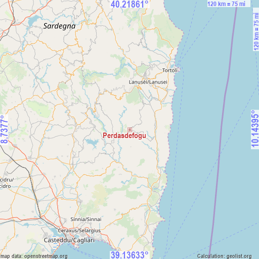
Perdasdefogu GPS coordinates[2]
39° 40' 46.524" North, 9° 26' 26.952" East
| Map corner | latitude | longitude |
|---|---|---|
| Upper-left | 40.21861°, | 8.7377° |
| Center: | 39.67959°, | 9.44082° |
| Lower-right: | 39.13633°, | 10.14395° |
| Map W x H: | 120.3×120.3 km | = 74.8×74.8mi |
| max Lat: | 47.04031° ⇑89.6% North |
| Perdasdefogu: | 39.67959° |
| min Lat: | ⇓10.4% South 35.50142° |
| min Long | Perdasdefogu | max Long |
| 6.69888° | 9.44082° | 18.48682° |
| W 26%⇐ | ⇒74% E |
Elevation
Elevation of Perdasdefogu is 600 m = 1969 ft, and this is 293.3 m = 962 ft above average elevation for this country.
| Max E: |
2085 m = 6841 ft | 15.5% |
| Perdasdefogu | 600 m 1969 ft | |
| Avg. | 306.7 m = 1006 ft | |
Min E: |
-4 m = -13 ft | 84.5% |
See also: Italy elevation on elevation.city.
Geographical zone
Perdasdefogu is located in North temperate zone (between Tropic of Cancer and the Arctic Circle). Distance of this Northern Tropic circle is 1806 km =1122.2 mi to South.| Distance of | km | miles | from Perdasdefogu |
|---|---|---|---|
| North Pole | 5595.1 | 3476.6 | to North |
| Arctic Circle | 2989.2 | 1857.4 | to North |
| Tropic Cancer | 1806 | 1122.2 | to South |
| Equator | 4412 | 2741.5 | to South |


Nearby cities:
15 places around Perdasdefogu: (largest is in red/bold)
• Armungia
18.3 km =11.4 mi,  196°
196°
• Ballao
16 km =9.9 mi,  205°
205°
• Cardedu
20.6 km =12.8 mi,  50°
50°
• Escalaplano
9.6 km =6 mi,  231°
231°
• Esterzili
17.5 km =10.9 mi,  309°
309°
• Gairo Sant'Elena
19.7 km =12.2 mi,  16°
16°
• Goni
17.4 km =10.8 mi, 230°
• Jerzu
14.2 km =8.8 mi,  27°
27°
• Nurri
18.4 km =11.4 mi,  281°
281°
• Orroli
16.4 km =10.2 mi,  274°
274°
• Osini
16.6 km =10.3 mi, 16°
• Seui
20.4 km =12.7 mi,  330°
330°
• Tertenia
11.9 km =7.4 mi,  81°
81°
• Ulassai
15.4 km =9.6 mi, 19°
• Ussassai
15 km =9.3 mi,  344°
344°
Sources, notices
• [Note1] Compared only with cities in Italy existing in our database
• [Src1] Map data: © OpenStreetMap contributors (CC-BY-SA)
• [Src2] Other city data from geonames.org with taken over terms of usage.
• [Src3] Geographical zone / Annual Mean Temperature by Robert A. Rohde @ Wikipedia
