Serrenti geodata
Serrenti (Sardinia) is a seat of a third-order administrative division; located in Italy in Europe/Rome (GMT+2) time zone. With population of 4,819 people, there are 2030 cities with bigger population in this country. Compared to other cities in Italy, 90.4% of cities are located further ↑North; 81.6% of cities are located further →East and 65.5% of cities have higher elevation than Serrenti. Note1


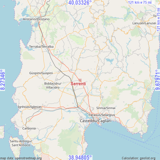
Serrenti GPS coordinates[2]
39° 29' 33.972" North, 8° 58' 35.724" East
| Map corner | latitude | longitude |
|---|---|---|
| Upper-left | 40.03326°, | 8.27346° |
| Center: | 39.49277°, | 8.97659° |
| Lower-right: | 38.94805°, | 9.67971° |
| Map W x H: | 120.7×120.7 km | = 75×75mi |
| max Lat: | 47.04031° ⇑90.4% North |
| Serrenti: | 39.49277° |
| min Lat: | ⇓9.6% South 35.50142° |
| min Long | Serrenti | max Long |
| 6.69888° | 8.97659° | 18.48682° |
| W 18.4%⇐ | ⇒81.6% E |
Elevation
Elevation of Serrenti is 125 m = 410 ft, and this is 181.7 m = 596 ft below average elevation for this country.
| Max E: |
2085 m = 6841 ft | 65.5% |
| Avg. | 306.7 m = 1006 ft | |
| Serrenti | 125 m = 410 ft | |
Min E: |
-4 m = -13 ft | 34.5% |
See also: Italy elevation on elevation.city.
Geographical zone
Serrenti is located in North temperate zone (between Tropic of Cancer and the Arctic Circle). Distance of this Northern Tropic circle is 1785.3 km =1109.3 mi to South.| Distance of | km | miles | from Serrenti |
|---|---|---|---|
| North Pole | 5615.9 | 3489.6 | to North |
| Arctic Circle | 3010 | 1870.3 | to North |
| Tropic Cancer | 1785.3 | 1109.3 | to South |
| Equator | 4391.2 | 2728.6 | to South |


Nearby cities:
15 places around Serrenti: (largest is in red/bold)
• Barrali
10.9 km =6.8 mi,  100°
100°
• Furtei
8.1 km =5 mi,  342°
342°
• Guamaggiore
11.9 km =7.4 mi,  44°
44°
• Guasila
9.4 km =5.8 mi, 37°
• Monastir
13.5 km =8.4 mi,  154°
154°
• Nuraminis
6.4 km =4 mi, 150°
• Ortacesus
10.8 km =6.7 mi,  61°
61°
• Pimentel
7.6 km =4.7 mi,  94°
94°
• Samassi
6.2 km =3.9 mi,  258°
258°
• Samatzai
5.1 km =3.2 mi, 102°
• Sanluri
10.1 km =6.3 mi,  319°
319°
• Segariu
7.9 km =4.9 mi,  3°
3°
• Selegas
13.7 km =8.5 mi,  52°
52°
• Serramanna
9 km =5.6 mi,  211°
211°
• Villasor
12.7 km =7.9 mi,  193°
193°
Sources, notices
• [Note1] Compared only with cities in Italy existing in our database
• [Src1] Map data: © OpenStreetMap contributors (CC-BY-SA)
• [Src2] Other city data from geonames.org with taken over terms of usage.
• [Src3] Geographical zone / Annual Mean Temperature by Robert A. Rohde @ Wikipedia
