Regalbuto geodata
Regalbuto (Sicily) is a seat of a third-order administrative division; located in Italy in Europe/Rome (GMT+2) time zone. With population of 6,811 people, there are 1437 cities with bigger population in this country. Compared to other cities in Italy, 98.3% of cities are located further ↑North; 83.9% of cities are located further ←West and 78.6% of cities have lower elevation than Regalbuto. Note1


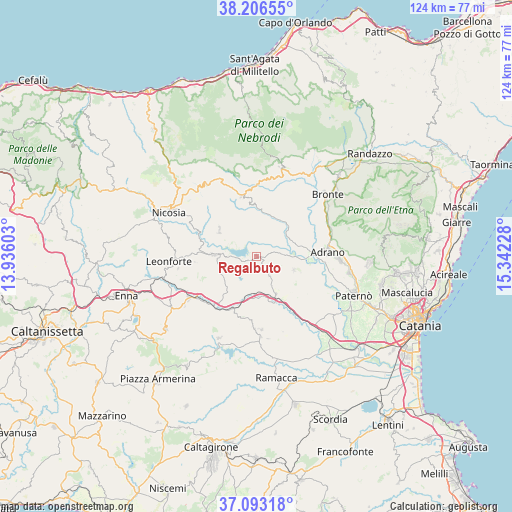
Regalbuto GPS coordinates[2]
37° 39' 7.02" North, 14° 38' 20.94" East
| Map corner | latitude | longitude |
|---|---|---|
| Upper-left | 38.20655°, | 13.93603° |
| Center: | 37.65195°, | 14.63915° |
| Lower-right: | 37.09318°, | 15.34228° |
| Map W x H: | 123.8×123.8 km | = 76.9×76.9mi |
| max Lat: | 47.04031° ⇑98.3% North |
| Regalbuto: | 37.65195° |
| min Lat: | ⇓1.7% South 35.50142° |
| min Long | Regalbuto | max Long |
| 6.69888° | 14.63915° | 18.48682° |
| W 83.9%⇐ | ⇒16.1% E |
Elevation
Elevation of Regalbuto is 501 m = 1644 ft, and this is 194.3 m = 637 ft above average elevation for this country.
| Max E: |
2085 m = 6841 ft | 21.4% |
| Regalbuto | 501 m 1644 ft | |
| Avg. | 306.7 m = 1006 ft | |
Min E: |
-4 m = -13 ft | 78.6% |
See also: Italy elevation on elevation.city.
Geographical zone
Regalbuto is located in North temperate zone (between Tropic of Cancer and the Arctic Circle). Distance of this Northern Tropic circle is 1580.6 km =982.1 mi to South.| Distance of | km | miles | from Regalbuto |
|---|---|---|---|
| North Pole | 5820.6 | 3616.8 | to North |
| Arctic Circle | 3214.7 | 1997.5 | to North |
| Tropic Cancer | 1580.6 | 982.1 | to South |
| Equator | 4186.5 | 2601.4 | to South |


Nearby cities:
15 places around Regalbuto: (largest is in red/bold)
• Adrano
17.1 km =10.6 mi,  85°
85°
• Agira
10.5 km =6.5 mi,  272°
272°
• Assoro
19.7 km =12.2 mi,  260°
260°
• Biancavilla
20.1 km =12.5 mi, 92°
• Carrubbo
17.5 km =10.9 mi,  181°
181°
• Castel di Judica
17.5 km =10.9 mi, 177°
• Catenanuova
10.3 km =6.4 mi,  153°
153°
• Centuripe
9.5 km =5.9 mi,  109°
109°
• Cerami
21 km =13 mi,  326°
326°
• Cinquegrana
20.1 km =12.5 mi,  172°
172°
• Gagliano Castelferrato
11.2 km =7 mi,  305°
305°
• Giumarra
19.5 km =12.1 mi, 177°
• Nissoria
16.8 km =10.4 mi, 270°
• San Giorgio
15.1 km =9.4 mi, 265°
• Troina
15.2 km =9.4 mi,  345°
345°
Sources, notices
• [Note1] Compared only with cities in Italy existing in our database
• [Src1] Map data: © OpenStreetMap contributors (CC-BY-SA)
• [Src2] Other city data from geonames.org with taken over terms of usage.
• [Src3] Geographical zone / Annual Mean Temperature by Robert A. Rohde @ Wikipedia
