Centuripe geodata
Centuripe (Sicily) is a seat of a third-order administrative division; located in Italy in Europe/Rome (GMT+2) time zone. With population of 4,910 people, there are 1986 cities with bigger population in this country. Compared to other cities in Italy, 98.4% of cities are located further ↑North; 84.8% of cities are located further ←West and 88.5% of cities have lower elevation than Centuripe. Note1


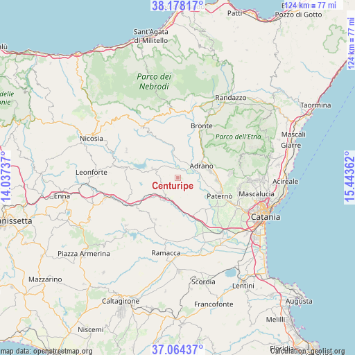
Centuripe GPS coordinates[2]
37° 37' 24.096" North, 14° 44' 25.764" East
| Map corner | latitude | longitude |
|---|---|---|
| Upper-left | 38.17817°, | 14.03737° |
| Center: | 37.62336°, | 14.74049° |
| Lower-right: | 37.06437°, | 15.44362° |
| Map W x H: | 123.8×123.8 km | = 76.9×76.9mi |
| max Lat: | 47.04031° ⇑98.4% North |
| Centuripe: | 37.62336° |
| min Lat: | ⇓1.6% South 35.50142° |
| min Long | Centuripe | max Long |
| 6.69888° | 14.74049° | 18.48682° |
| W 84.8%⇐ | ⇒15.2% E |
Elevation
Elevation of Centuripe is 683 m = 2241 ft, and this is 376.3 m = 1235 ft above average elevation for this country.
| Max E: |
2085 m = 6841 ft | 11.5% |
| Centuripe | 683 m 2241 ft | |
| Avg. | 306.7 m = 1006 ft | |
Min E: |
-4 m = -13 ft | 88.5% |
See also: Italy elevation on elevation.city.
Geographical zone
Centuripe is located in North temperate zone (between Tropic of Cancer and the Arctic Circle). Distance of this Northern Tropic circle is 1577.4 km =980.2 mi to South.| Distance of | km | miles | from Centuripe |
|---|---|---|---|
| North Pole | 5823.7 | 3618.7 | to North |
| Arctic Circle | 3217.8 | 1999.4 | to North |
| Tropic Cancer | 1577.4 | 980.2 | to South |
| Equator | 4183.3 | 2599.4 | to South |


Nearby cities:
15 places around Centuripe: (largest is in red/bold)
• Adrano
9.3 km =5.8 mi,  61°
61°
• Agira
19.8 km =12.3 mi,  280°
280°
• Biancavilla
11.4 km =7.1 mi,  78°
78°
• Bronte
20.1 km =12.5 mi,  24°
24°
• Carrubbo
17.1 km =10.6 mi,  213°
213°
• Castel di Judica
16.5 km =10.3 mi, 209°
• Catenanuova
7.5 km =4.7 mi,  215°
215°
• Cinquegrana
17.8 km =11.1 mi,  200°
200°
• Gagliano Castelferrato
20.5 km =12.7 mi,  297°
297°
• Giumarra
18.2 km =11.3 mi, 206°
• Palazzolo
18 km =11.2 mi,  112°
112°
• Paternò
15.6 km =9.7 mi, 113°
• Ragalna
18.2 km =11.3 mi,  86°
86°
• Regalbuto
9.5 km =5.9 mi,  289°
289°
• Santa Maria di Licodia
13.5 km =8.4 mi, 93°
Sources, notices
• [Note1] Compared only with cities in Italy existing in our database
• [Src1] Map data: © OpenStreetMap contributors (CC-BY-SA)
• [Src2] Other city data from geonames.org with taken over terms of usage.
• [Src3] Geographical zone / Annual Mean Temperature by Robert A. Rohde @ Wikipedia
