Portoscuso geodata
Portoscuso (Sardinia) is a seat of a third-order administrative division; located in Italy in Europe/Rome (GMT+2) time zone. With population of 4,440 people, there are 2171 cities with bigger population in this country. Compared to other cities in Italy, 91.8% of cities are located further ↑North; 89.3% of cities are located further →East and 85% of cities have higher elevation than Portoscuso. Note1
Administrative division(s):
- Level 1: Sardinia
- Level 2: Provincia del Sud Sardegna
- Level 3: Portoscuso


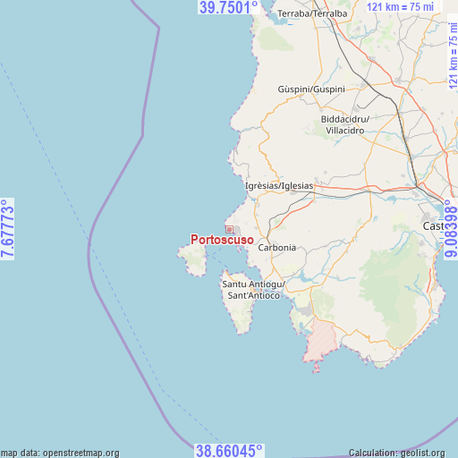
Portoscuso GPS coordinates[2]
39° 12' 26.604" North, 8° 22' 51.096" East
| Map corner | latitude | longitude |
|---|---|---|
| Upper-left | 39.7501°, | 7.67773° |
| Center: | 39.20739°, | 8.38086° |
| Lower-right: | 38.66045°, | 9.08398° |
| Map W x H: | 121.2×121.2 km | = 75.3×75.3mi |
| max Lat: | 47.04031° ⇑91.8% North |
| Portoscuso: | 39.20739° |
| min Lat: | ⇓8.2% South 35.50142° |
| min Long | Portoscuso | max Long |
| 6.69888° | 8.38086° | 18.48682° |
| W 10.7%⇐ | ⇒89.3% E |
Elevation
Elevation of Portoscuso is 31 m = 102 ft, and this is 275.7 m = 905 ft below average elevation for this country.
| Max E: |
2085 m = 6841 ft | 85% |
| Avg. | 306.7 m = 1006 ft | |
| Portoscuso | 31 m = 102 ft | |
Min E: |
-4 m = -13 ft | 15% |
See also: Italy elevation on elevation.city.
Geographical zone
Portoscuso is located in North temperate zone (between Tropic of Cancer and the Arctic Circle). Distance of this Northern Tropic circle is 1753.5 km =1089.6 mi to South.| Distance of | km | miles | from Portoscuso |
|---|---|---|---|
| North Pole | 5647.6 | 3509.3 | to North |
| Arctic Circle | 3041.7 | 1890 | to North |
| Tropic Cancer | 1753.5 | 1089.6 | to South |
| Equator | 4359.5 | 2708.9 | to South |


Nearby cities:
15 places around Portoscuso: (largest is in red/bold)
• Bacu Abis
8.3 km =5.2 mi,  61°
61°
• Barbusi
10.9 km =6.8 mi,  92°
92°
• Calasetta
11.2 km =7 mi,  185°
185°
• Carbonia
13 km =8.1 mi,  111°
111°
• Carloforte
9.9 km =6.2 mi,  221°
221°
• Cortoghiana
7.3 km =4.5 mi, 86°
• Gonnesa
10 km =6.2 mi,  50°
50°
• Iglesias
17.6 km =10.9 mi, 49°
• Is Urigus
12.7 km =7.9 mi,  129°
129°
• Matzaccara
10.4 km =6.5 mi,  143°
143°
• Nebida
12.8 km =8 mi,  22°
22°
• Nuraxi Figus
4.8 km =3 mi,  69°
69°
• Paringianu
5.6 km =3.5 mi, 130°
• San Giovanni Suergiu
16.2 km =10.1 mi, 132°
• Sant'Antioco
16.5 km =10.3 mi,  157°
157°
Sources, notices
• [Note1] Compared only with cities in Italy existing in our database
• [Src1] Map data: © OpenStreetMap contributors (CC-BY-SA)
• [Src2] Other city data from geonames.org with taken over terms of usage.
• [Src3] Geographical zone / Annual Mean Temperature by Robert A. Rohde @ Wikipedia
