Nebida geodata
Nebida (Sardinia) is a populated place; located in Italy in Europe/Rome (GMT+2) time zone. With population of 924 people, there are 7009 cities with bigger population in this country. Compared to other cities in Italy, 91.1% of cities are located further ↑North; 88.6% of cities are located further →East and 58.9% of cities have higher elevation than Nebida. Note1


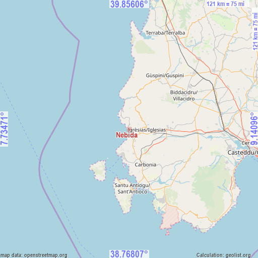
Nebida GPS coordinates[2]
39° 18' 51.048" North, 8° 26' 16.224" East
| Map corner | latitude | longitude |
|---|---|---|
| Upper-left | 39.85606°, | 7.73471° |
| Center: | 39.31418°, | 8.43784° |
| Lower-right: | 38.76807°, | 9.14096° |
| Map W x H: | 121×121 km | = 75.2×75.2mi |
| max Lat: | 47.04031° ⇑91.1% North |
| Nebida: | 39.31418° |
| min Lat: | ⇓8.9% South 35.50142° |
| min Long | Nebida | max Long |
| 6.69888° | 8.43784° | 18.48682° |
| W 11.4%⇐ | ⇒88.6% E |
Elevation
Elevation of Nebida is 172 m = 564 ft, and this is 134.7 m = 442 ft below average elevation for this country.
| Max E: |
2085 m = 6841 ft | 58.9% |
| Avg. | 306.7 m = 1006 ft | |
| Nebida | 172 m = 564 ft | |
Min E: |
-4 m = -13 ft | 41.1% |
See also: Italy elevation on elevation.city.
Geographical zone
Nebida is located in North temperate zone (between Tropic of Cancer and the Arctic Circle). Distance of this Northern Tropic circle is 1765.4 km =1097 mi to South.| Distance of | km | miles | from Nebida |
|---|---|---|---|
| North Pole | 5635.7 | 3501.9 | to North |
| Arctic Circle | 3029.8 | 1882.6 | to North |
| Tropic Cancer | 1765.4 | 1097 | to South |
| Equator | 4371.3 | 2716.2 | to South |


Nearby cities:
15 places around Nebida: (largest is in red/bold)
• Bacu Abis
8.2 km =5.1 mi,  163°
163°
• Barbusi
13.8 km =8.6 mi,  154°
154°
• Buggerru
9.9 km =6.2 mi,  341°
341°
• Carbonia
18.1 km =11.2 mi, 156°
• Cortoghiana
11.6 km =7.2 mi,  168°
168°
• Domusnovas
18.2 km =11.3 mi,  86°
86°
• Fluminimaggiore
14.8 km =9.2 mi,  20°
20°
• Gonnesa
6.1 km =3.8 mi, 152°
• Iglesias
8.6 km =5.3 mi, 93°
• Matzaccara
20.3 km =12.6 mi,  176°
176°
• Musei
19.7 km =12.2 mi, 93°
• Nuraxi Figus
10.2 km =6.3 mi, 182°
• Paringianu
15.5 km =9.6 mi, 182°
• Portoscuso
12.8 km =8 mi,  202°
202°
• Villamassargia
18 km =11.2 mi,  104°
104°
Sources, notices
• [Note1] Compared only with cities in Italy existing in our database
• [Src1] Map data: © OpenStreetMap contributors (CC-BY-SA)
• [Src2] Other city data from geonames.org with taken over terms of usage.
• [Src3] Geographical zone / Annual Mean Temperature by Robert A. Rohde @ Wikipedia
