Pau geodata
Pau (Sardinia) is a seat of a third-order administrative division; located in Italy in Europe/Rome (GMT+2) time zone. With population of 299 people, there are 10680 cities with bigger population in this country. Compared to other cities in Italy, 89.1% of cities are located further ↑North; 84.1% of cities are located further →East and 60.6% of cities have lower elevation than Pau. Note1


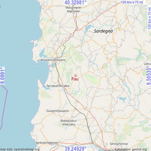
Pau GPS coordinates[2]
39° 47' 30.012" North, 8° 48' 7.992" East
| Map corner | latitude | longitude |
|---|---|---|
| Upper-left | 40.32981°, | 8.0991° |
| Center: | 39.79167°, | 8.80222° |
| Lower-right: | 39.24929°, | 9.50535° |
| Map W x H: | 120.1×120.1 km | = 74.6×74.6mi |
| max Lat: | 47.04031° ⇑89.1% North |
| Pau: | 39.79167° |
| min Lat: | ⇓10.9% South 35.50142° |
| min Long | Pau | max Long |
| 6.69888° | 8.80222° | 18.48682° |
| W 15.9%⇐ | ⇒84.1% E |
Elevation
Elevation of Pau is 304 m = 997 ft, and this is 2.7 m = 9 ft below average elevation for this country.
| Max E: |
2085 m = 6841 ft | 39.4% |
| Avg. | 306.7 m = 1006 ft | |
| Pau | 304 m = 997 ft | |
Min E: |
-4 m = -13 ft | 60.6% |
See also: Italy elevation on elevation.city.
Geographical zone
Pau is located in North temperate zone (between Tropic of Cancer and the Arctic Circle). Distance of this Northern Tropic circle is 1818.5 km =1130 mi to South.| Distance of | km | miles | from Pau |
|---|---|---|---|
| North Pole | 5582.6 | 3468.9 | to North |
| Arctic Circle | 2976.8 | 1849.7 | to North |
| Tropic Cancer | 1818.5 | 1130 | to South |
| Equator | 4424.4 | 2749.2 | to South |


Nearby cities:
15 places around Pau: (largest is in red/bold)
• Albagiara
5.1 km =3.2 mi,  95°
95°
• Ales
2.8 km =1.7 mi,  156°
156°
• Assolo
10.2 km =6.3 mi,  79°
79°
• Curcuris
5.6 km =3.5 mi,  153°
153°
• Gonnoscodina
10.6 km =6.6 mi, 164°
• Gonnosnò
6.8 km =4.2 mi,  119°
119°
• Masullas
10.3 km =6.4 mi,  188°
188°
• Mogorella
9.4 km =5.8 mi,  30°
30°
• Morgongiori
5.7 km =3.5 mi,  208°
208°
• Pompu
7.4 km =4.6 mi,  183°
183°
• Simala
8.2 km =5.1 mi, 164°
• Sini
9.7 km =6 mi, 115°
• Siris
9.1 km =5.7 mi, 194°
• Usellus
4.6 km =2.9 mi,  66°
66°
• Villa Verde
1.7 km =1.1 mi, 75°
Sources, notices
• [Note1] Compared only with cities in Italy existing in our database
• [Src1] Map data: © OpenStreetMap contributors (CC-BY-SA)
• [Src2] Other city data from geonames.org with taken over terms of usage.
• [Src3] Geographical zone / Annual Mean Temperature by Robert A. Rohde @ Wikipedia
