Palma di Montechiaro geodata
Palma di Montechiaro (Sicily) is a seat of a third-order administrative division; located in Italy in Europe/Rome (GMT+2) time zone. With population of 22,654 people, there are 383 cities with bigger population in this country. Compared to other cities in Italy, 99.5% of cities are located further ↑North; 76.3% of cities are located further ←West and 58.4% of cities have higher elevation than Palma di Montechiaro. Note1
Current local time in Palma di Montechiaro:
08:28 PM, WednesdayDifference from your time zone: hours


Palma di Montechiaro GPS coordinates[2]
37° 11' 26.376" North, 13° 45' 57.708" East
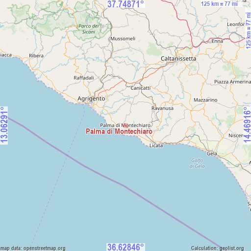
| Map corner | latitude | longitude |
|---|---|---|
| Upper-left | 37.74871°, | 13.06291° |
| Center: | 37.19066°, | 13.76603° |
| Lower-right: | 36.62846°, | 14.46916° |
| Map W x H: | 124.6×124.6 km | = 77.4×77.4mi |
| max Lat: | 47.04031° ⇑99.5% North |
| Palma di Montechiaro: | 37.19066° |
| min Lat: | ⇓0.5% South 35.50142° |
| min Long | Palma di Montec | max Long |
| 6.69888° | 13.76603° | 18.48682° |
| W 76.3%⇐ | ⇒23.7% E |
Elevation
Elevation of Palma di Montechiaro is 176 m = 577 ft, and this is 130.7 m = 429 ft below average elevation for this country.
| Max E: |
2085 m = 6841 ft | 58.4% |
| Avg. | 306.7 m = 1006 ft | |
| Palma di Montechiaro | 176 m = 577 ft | |
Min E: |
-4 m = -13 ft | 41.6% |
See also: Italy elevation on elevation.city.
Geographical zone
Palma di Montechiaro is located in North temperate zone (between Tropic of Cancer and the Arctic Circle). Distance of this Northern Tropic circle is 1529.3 km =950.3 mi to South.| Distance of | km | miles | from Palma di Montechiaro |
|---|---|---|---|
| North Pole | 5871.8 | 3648.6 | to North |
| Arctic Circle | 3266 | 2029.4 | to North |
| Tropic Cancer | 1529.3 | 950.3 | to South |
| Equator | 4135.2 | 2569.5 | to South |


Nearby cities:
15 places around Palma di Montechiaro: (largest is in red/bold)
• Agrigento
21.4 km =13.3 mi,  308°
308°
• Camastra
7.4 km =4.6 mi,  18°
18°
• Campobello di Licata
15.4 km =9.6 mi,  61°
61°
• Canicattì
20 km =12.4 mi, 21°
• Castrofilippo
17.8 km =11.1 mi,  355°
355°
• Delia
23.5 km =14.6 mi,  37°
37°
• Favara
16.8 km =10.4 mi,  326°
326°
• Grotte
24.4 km =15.2 mi,  345°
345°
• Licata
18.2 km =11.3 mi,  122°
122°
• Naro
11.6 km =7.2 mi,  12°
12°
• Porto Empedocle
24 km =14.9 mi,  297°
297°
• Racalmuto
24 km =14.9 mi, 352°
• Ravanusa
19.8 km =12.3 mi, 64°
• San Leone Mosè
18.1 km =11.2 mi, 297°
• Villaseta
21.9 km =13.6 mi, 303°
Sources, notices
• [Note1] Compared only with cities in Italy existing in our database
• [Src1] Map data: © OpenStreetMap contributors (CC-BY-SA)
• [Src2] Other city data from geonames.org with taken over terms of usage.
• [Src3] Geographical zone / Annual Mean Temperature by Robert A. Rohde @ Wikipedia
