Zoppola geodata
Zoppola (Friuli Venezia Giulia) is a seat of a third-order administrative division; located in Italy in Europe/Rome (GMT+2) time zone. With population of 2,241 people, there are 3822 cities with bigger population in this country. Compared to other cities in Italy, 91% of cities are located further ↓South; 65.8% of cities are located further ←West and 85% of cities have higher elevation than Zoppola. Note1
Administrative division(s):
- Level 1: Friuli Venezia Giulia
- Level 2: Provincia di Pordenone
- Level 3: Zoppola


Zoppola GPS coordinates[2]
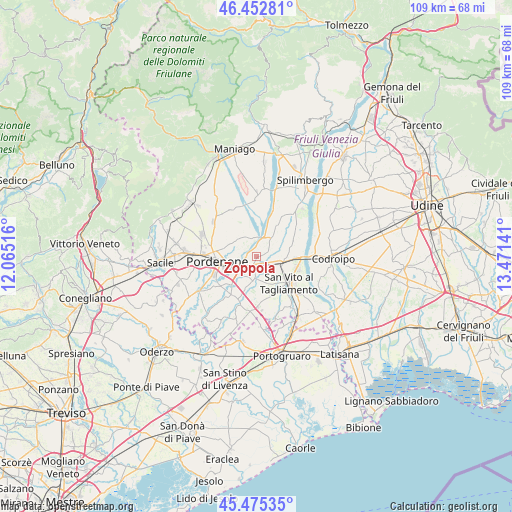
45° 57' 58.464" North, 12° 46' 5.808" East
| Map corner | latitude | longitude |
|---|---|---|
| Upper-left | 46.45281°, | 12.06516° |
| Center: | 45.96624°, | 12.76828° |
| Lower-right: | 45.47535°, | 13.47141° |
| Map W x H: | 108.7×108.7 km | = 67.5×67.5mi |
| max Lat: | 47.04031° ⇑9% North |
| Zoppola: | 45.96624° |
| min Lat: | ⇓91% South 35.50142° |
| min Long | Zoppola | max Long |
| 6.69888° | 12.76828° | 18.48682° |
| W 65.8%⇐ | ⇒34.2% E |
Elevation
Elevation of Zoppola is 31 m = 102 ft, and this is 275.7 m = 905 ft below average elevation for this country.
| Max E: |
2085 m = 6841 ft | 85% |
| Avg. | 306.7 m = 1006 ft | |
| Zoppola | 31 m = 102 ft | |
Min E: |
-4 m = -13 ft | 15% |
See also: Italy elevation on elevation.city.
Geographical zone
Zoppola is located in North temperate zone (between Tropic of Cancer and the Arctic Circle). Distance of this North polar circle is 2290.2 km =1423.1 mi to North.| Distance of | km | miles | from Zoppola |
|---|---|---|---|
| North Pole | 4896.1 | 3042.3 | to North |
| Arctic Circle | 2290.2 | 1423.1 | to North |
| Tropic Cancer | 2505 | 1556.5 | to South |
| Equator | 5111 | 3175.8 | to South |


Nearby cities:
15 places around Zoppola: (largest is in red/bold)
• Arzene
7.3 km =4.5 mi,  59°
59°
• Casarsa della Delizia
6 km =3.7 mi,  106°
106°
• Castions
2.5 km =1.6 mi,  74°
74°
• Cinque Strade-Cimpello
7.6 km =4.7 mi,  223°
223°
• Cordenons
5.6 km =3.5 mi,  290°
290°
• Fiume Veneto
4.8 km =3 mi,  209°
209°
• Musil
5.6 km =3.5 mi,  272°
272°
• Orcenico Inferiore
1.9 km =1.2 mi,  189°
189°
• Pordenone
8.4 km =5.2 mi,  262°
262°
• Rauscedo-Domanins
9.4 km =5.8 mi,  27°
27°
• Rosa
8.9 km =5.5 mi,  116°
116°
• San Martino al Tagliamento
9.7 km =6 mi,  54°
54°
• San Vito al Tagliamento
8.9 km =5.5 mi,  127°
127°
• Valvasone
8.2 km =5.1 mi, 68°
• Villa D'Arco
8.8 km =5.5 mi,  295°
295°
Sources, notices
• [Note1] Compared only with cities in Italy existing in our database
• [Src1] Map data: © OpenStreetMap contributors (CC-BY-SA)
• [Src2] Other city data from geonames.org with taken over terms of usage.
• [Src3] Geographical zone / Annual Mean Temperature by Robert A. Rohde @ Wikipedia
