Rosa geodata
Rosa (Friuli Venezia Giulia) is a populated place; located in Italy in Europe/Rome (GMT+2) time zone. With population of 13,443 people, there are 677 cities with bigger population in this country. Compared to other cities in Italy, 90.1% of cities are located further ↓South; 66.9% of cities are located further ←West and 83.7% of cities have higher elevation than Rosa. Note1
Administrative division(s):
- Level 1: Friuli Venezia Giulia
- Level 2: Provincia di Pordenone
- Level 3: San Vito al Tagliamento


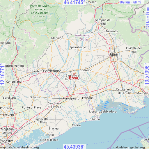
Rosa GPS coordinates[2]
45° 55' 50.016" North, 12° 52' 14.988" East
| Map corner | latitude | longitude |
|---|---|---|
| Upper-left | 46.41745°, | 12.16771° |
| Center: | 45.93056°, | 12.87083° |
| Lower-right: | 45.43936°, | 13.57396° |
| Map W x H: | 108.8×108.8 km | = 67.6×67.6mi |
| max Lat: | 47.04031° ⇑9.9% North |
| Rosa: | 45.93056° |
| min Lat: | ⇓90.1% South 35.50142° |
| min Long | Rosa | max Long |
| 6.69888° | 12.87083° | 18.48682° |
| W 66.9%⇐ | ⇒33.1% E |
Elevation
Elevation of Rosa is 35 m = 115 ft, and this is 271.7 m = 891 ft below average elevation for this country.
| Max E: |
2085 m = 6841 ft | 83.7% |
| Avg. | 306.7 m = 1006 ft | |
| Rosa | 35 m = 115 ft | |
Min E: |
-4 m = -13 ft | 16.3% |
See also: Italy elevation on elevation.city.
Geographical zone
Rosa is located in North temperate zone (between Tropic of Cancer and the Arctic Circle). Distance of this North polar circle is 2294.2 km =1425.5 mi to North.| Distance of | km | miles | from Rosa |
|---|---|---|---|
| North Pole | 4900.1 | 3044.8 | to North |
| Arctic Circle | 2294.2 | 1425.5 | to North |
| Tropic Cancer | 2501.1 | 1554.1 | to South |
| Equator | 5107 | 3173.3 | to South |


Nearby cities:
15 places around Rosa: (largest is in red/bold)
• Arzene
7.8 km =4.8 mi,  348°
348°
• Bagnarola
7.1 km =4.4 mi,  187°
187°
• Biauzzo
5.2 km =3.2 mi,  61°
61°
• Camino al Tagliamento
5.7 km =3.5 mi,  93°
93°
• Casarsa della Delizia
3.1 km =1.9 mi,  315°
315°
• Casette
8.5 km =5.3 mi,  175°
175°
• Castions
7.2 km =4.5 mi,  310°
310°
• Gleris
3.9 km =2.4 mi, 175°
• Morsano
9 km =5.6 mi,  150°
150°
• Orcenico Inferiore
8.5 km =5.3 mi,  284°
284°
• Ramuscello
5.6 km =3.5 mi,  169°
169°
• San Vito al Tagliamento
1.8 km =1.1 mi,  209°
209°
• Savorgnano
4.1 km =2.5 mi,  199°
199°
• Valvasone
7 km =4.3 mi,  357°
357°
• Zoppola
8.9 km =5.5 mi,  296°
296°
Sources, notices
• [Note1] Compared only with cities in Italy existing in our database
• [Src1] Map data: © OpenStreetMap contributors (CC-BY-SA)
• [Src2] Other city data from geonames.org with taken over terms of usage.
• [Src3] Geographical zone / Annual Mean Temperature by Robert A. Rohde @ Wikipedia
