Arzene geodata
Arzene (Friuli Venezia Giulia) is a seat of a third-order administrative division; located in Italy in Europe/Rome (GMT+2) time zone. With population of 1,263 people, there are 5746 cities with bigger population in this country. Compared to other cities in Italy, 92% of cities are located further ↓South; 66.6% of cities are located further ←West and 78.6% of cities have higher elevation than Arzene. Note1
Administrative division(s):
- Level 1: Friuli Venezia Giulia
- Level 2: Provincia di Pordenone
- Level 3: Valvasone Arzene


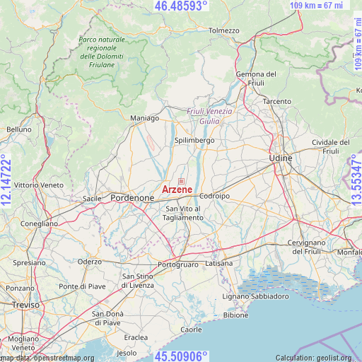
Arzene GPS coordinates[2]
45° 59' 58.74" North, 12° 51' 1.224" East
| Map corner | latitude | longitude |
|---|---|---|
| Upper-left | 46.48593°, | 12.14722° |
| Center: | 45.99965°, | 12.85034° |
| Lower-right: | 45.50906°, | 13.55347° |
| Map W x H: | 108.6×108.6 km | = 67.5×67.5mi |
| max Lat: | 47.04031° ⇑8% North |
| Arzene: | 45.99965° |
| min Lat: | ⇓92% South 35.50142° |
| min Long | Arzene | max Long |
| 6.69888° | 12.85034° | 18.48682° |
| W 66.6%⇐ | ⇒33.4% E |
Elevation
Elevation of Arzene is 56 m = 184 ft, and this is 250.7 m = 823 ft below average elevation for this country.
| Max E: |
2085 m = 6841 ft | 78.6% |
| Avg. | 306.7 m = 1006 ft | |
| Arzene | 56 m = 184 ft | |
Min E: |
-4 m = -13 ft | 21.4% |
See also: Italy elevation on elevation.city.
Geographical zone
Arzene is located in North temperate zone (between Tropic of Cancer and the Arctic Circle). Distance of this North polar circle is 2286.5 km =1420.8 mi to North.| Distance of | km | miles | from Arzene |
|---|---|---|---|
| North Pole | 4892.4 | 3040 | to North |
| Arctic Circle | 2286.5 | 1420.8 | to North |
| Tropic Cancer | 2508.8 | 1558.9 | to South |
| Equator | 5114.7 | 3178.1 | to South |


Nearby cities:
15 places around Arzene: (largest is in red/bold)
• Barbeano
9.8 km =6.1 mi,  8°
8°
• Biauzzo
8 km =5 mi,  129°
129°
• Casarsa della Delizia
5.5 km =3.4 mi,  186°
186°
• Castions
5 km =3.1 mi,  232°
232°
• Gradisca
8.7 km =5.4 mi,  88°
88°
• Orcenico Inferiore
8.6 km =5.3 mi, 230°
• Provesano
7.9 km =4.9 mi,  19°
19°
• Rauscedo-Domanins
5 km =3.1 mi,  336°
336°
• Rosa
7.8 km =4.8 mi,  168°
168°
• San Giorgio della Richinvelda
5.5 km =3.4 mi, 14°
• San Martino al Tagliamento
2.4 km =1.5 mi,  38°
38°
• San Vito al Tagliamento
9.2 km =5.7 mi,  175°
175°
• Sedegliano
9.9 km =6.2 mi,  80°
80°
• Valvasone
1.4 km =0.9 mi,  119°
119°
• Zoppola
7.3 km =4.5 mi,  239°
239°
Sources, notices
• [Note1] Compared only with cities in Italy existing in our database
• [Src1] Map data: © OpenStreetMap contributors (CC-BY-SA)
• [Src2] Other city data from geonames.org with taken over terms of usage.
• [Src3] Geographical zone / Annual Mean Temperature by Robert A. Rohde @ Wikipedia
