Soragna geodata
Soragna (Emilia-Romagna) is a seat of a third-order administrative division; located in Italy in Europe/Rome (GMT+2) time zone. With population of 3,308 people, there are 2832 cities with bigger population in this country. Compared to other cities in Italy, 58.4% of cities are located further ↓South; 66.7% of cities are located further →East and 80.9% of cities have higher elevation than Soragna. Note1


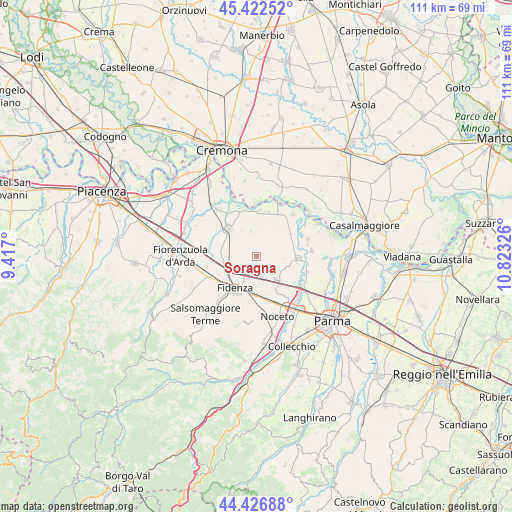
Soragna GPS coordinates[2]
44° 55' 36.696" North, 10° 7' 12.468" East
| Map corner | latitude | longitude |
|---|---|---|
| Upper-left | 45.42252°, | 9.417° |
| Center: | 44.92686°, | 10.12013° |
| Lower-right: | 44.42688°, | 10.82326° |
| Map W x H: | 110.7×110.7 km | = 68.8×68.8mi |
| max Lat: | 47.04031° ⇑41.6% North |
| Soragna: | 44.92686° |
| min Lat: | ⇓58.4% South 35.50142° |
| min Long | Soragna | max Long |
| 6.69888° | 10.12013° | 18.48682° |
| W 33.3%⇐ | ⇒66.7% E |
Elevation
Elevation of Soragna is 46 m = 151 ft, and this is 260.7 m = 855 ft below average elevation for this country.
| Max E: |
2085 m = 6841 ft | 80.9% |
| Avg. | 306.7 m = 1006 ft | |
| Soragna | 46 m = 151 ft | |
Min E: |
-4 m = -13 ft | 19.1% |
See also: Italy elevation on elevation.city.
Geographical zone
Soragna is located in North temperate zone (between Tropic of Cancer and the Arctic Circle). Distance of this Northern Tropic circle is 2389.5 km =1484.8 mi to South.| Distance of | km | miles | from Soragna |
|---|---|---|---|
| North Pole | 5011.7 | 3114.1 | to North |
| Arctic Circle | 2405.8 | 1494.9 | to North |
| Tropic Cancer | 2389.5 | 1484.8 | to South |
| Equator | 4995.4 | 3104 | to South |


Nearby cities:
15 places around Soragna: (largest is in red/bold)
• Alseno
12.7 km =7.9 mi,  255°
255°
• Busseto
8.4 km =5.2 mi,  314°
314°
• Castelnuovo Fogliani
12.9 km =8 mi,  243°
243°
• Fidenza
8.2 km =5.1 mi,  215°
215°
• Fontanellato
6.7 km =4.2 mi,  138°
138°
• Fontanelle
8.9 km =5.5 mi,  57°
57°
• Fontevivo
8.6 km =5.3 mi,  151°
151°
• Pieveottoville
9.9 km =6.2 mi,  16°
16°
• Polesine Parmense
10.3 km =6.4 mi,  346°
346°
• Roccabianca
11.8 km =7.3 mi,  40°
40°
• Ronco Campo Canneto
11.2 km =7 mi,  102°
102°
• San Secondo Parmense
8.7 km =5.4 mi,  93°
93°
• Sissa
11.6 km =7.2 mi,  71°
71°
• Trecasali
12.1 km =7.5 mi,  84°
84°
• Zibello
10.2 km =6.3 mi,  4°
4°
Sources, notices
• [Note1] Compared only with cities in Italy existing in our database
• [Src1] Map data: © OpenStreetMap contributors (CC-BY-SA)
• [Src2] Other city data from geonames.org with taken over terms of usage.
• [Src3] Geographical zone / Annual Mean Temperature by Robert A. Rohde @ Wikipedia
