Roccabianca geodata
Roccabianca (Emilia-Romagna) is a seat of a third-order administrative division; located in Italy in Europe/Rome (GMT+2) time zone. With population of 1,365 people, there are 5455 cities with bigger population in this country. Compared to other cities in Italy, 60.1% of cities are located further ↓South; 65.8% of cities are located further →East and 84.1% of cities have higher elevation than Roccabianca. Note1
Administrative division(s):
- Level 1: Emilia-Romagna
- Level 2: Provincia di Parma
- Level 3: Roccabianca


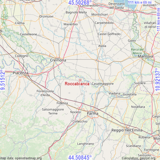
Roccabianca GPS coordinates[2]
45° 0' 27.792" North, 10° 13' 5.664" East
| Map corner | latitude | longitude |
|---|---|---|
| Upper-left | 45.50268°, | 9.51512° |
| Center: | 45.00772°, | 10.21824° |
| Lower-right: | 44.50845°, | 10.92137° |
| Map W x H: | 110.5×110.5 km | = 68.7×68.7mi |
| max Lat: | 47.04031° ⇑39.9% North |
| Roccabianca: | 45.00772° |
| min Lat: | ⇓60.1% South 35.50142° |
| min Long | Roccabianca | max Long |
| 6.69888° | 10.21824° | 18.48682° |
| W 34.2%⇐ | ⇒65.8% E |
Elevation
Elevation of Roccabianca is 34 m = 112 ft, and this is 272.7 m = 895 ft below average elevation for this country.
| Max E: |
2085 m = 6841 ft | 84.1% |
| Avg. | 306.7 m = 1006 ft | |
| Roccabianca | 34 m = 112 ft | |
Min E: |
-4 m = -13 ft | 15.9% |
See also: Italy elevation on elevation.city.
Geographical zone
Roccabianca is located in North temperate zone (between Tropic of Cancer and the Arctic Circle). Distance of this North polar circle is 2396.8 km =1489.3 mi to North.| Distance of | km | miles | from Roccabianca |
|---|---|---|---|
| North Pole | 5002.7 | 3108.5 | to North |
| Arctic Circle | 2396.8 | 1489.3 | to North |
| Tropic Cancer | 2398.5 | 1490.4 | to South |
| Equator | 5004.4 | 3109.6 | to South |


Nearby cities:
15 places around Roccabianca: (largest is in red/bold)
• Cella Dati
9.7 km =6 mi,  1°
1°
• Cingia de' Botti
9.7 km =6 mi,  27°
27°
• Coltaro
9.3 km =5.8 mi,  119°
119°
• Fontanelle
4.3 km =2.7 mi,  183°
183°
• Gussola
10.3 km =6.4 mi,  87°
87°
• Motta Baluffi
6.2 km =3.9 mi, 30°
• Pieveottoville
5 km =3.1 mi,  276°
276°
• Polesine Parmense
10.1 km =6.3 mi, 275°
• San Daniele Po
7.4 km =4.6 mi,  333°
333°
• San Secondo Parmense
9.6 km =6 mi,  174°
174°
• Scandolara Ravara
8.3 km =5.2 mi,  52°
52°
• Sissa
6.3 km =3.9 mi,  148°
148°
• Torricella del Pizzo
6.2 km =3.9 mi,  77°
77°
• Trecasali
8.9 km =5.5 mi, 151°
• Zibello
7.1 km =4.4 mi, 279°
Sources, notices
• [Note1] Compared only with cities in Italy existing in our database
• [Src1] Map data: © OpenStreetMap contributors (CC-BY-SA)
• [Src2] Other city data from geonames.org with taken over terms of usage.
• [Src3] Geographical zone / Annual Mean Temperature by Robert A. Rohde @ Wikipedia
